Designing and producing digital cultural heritage: the Map of Mexico 1550
Lily Díaz-Kommonen*
L'articolo che segue tratta della realizzazione della versione digitale della mappa cinquecentesca di Città del Messico, il cui originale è conservato nella Biblioteca dell'Università di Uppsala, in Svezia.
Attribuita da alcuni studiosi al cosmografo e cartografo spagnolo Alonso de Santa Cruz (1505 ca.-1567), la mappa raffigura la città e i dintorni, con il reticolo di strade e canali, esemplari di flora e fauna, disparate attività umane e quasi 150 glifi, figure simboliche di cose e animali, in relazione ad altrettanti toponimi. È un documento prezioso della storia della città e del territorio nei primi decenni della colonizzazione spagnola, con indicazioni per storici, archeologi, antropologi, storici dell'arte e dell'architettura, linguisti, per tutto il pubblico interessato alla cultura mesoamericana.
La replica digitale è stata realizzata, a partire dal 1997, dal gruppo di ricerca del MediaLab della University of Art and Design / UIAH di Helsinki guidato da Lily Díaz-Kommonen in collaborazione con l'Università di Uppsala e l'apporto dell'Universidad Iberoamericana de Ciudad de México.
Grazie a studi di paleografia e storia della cartografia, a competenze nelle applicazioni dell'informatica alla visualizzazione spaziale, a esperienze nel campo della computer art e a un profondo interesse per la fisionomia di quelli che lei definisce artefatti digitali, Díaz-Kommonen ha scelto la mappa cinquecentesca di Città del Messico per mettere in pratica alcuni concetti base della cultura ipermediale.
Nell'articolo vengono presentati i criteri teorici, tecnici e culturali che hanno guidato il lavoro. Com'è avvenuta la scelta delle tecniche di riproduzione della mappa che hanno portato a produrre un modello tridimensionale; come si sono sviluppate le diverse interfacce interattive di presentazione della versione digitale, a seconda delle differenti destinazioni: le mostre sugli Aztechi a Londra e in Germania nel 2002; il web, a partire dal 2004; fino al Festival Ars Electronica di Linz nel 2006; perché sono stati preferiti software open source (siamo in Finlandia!) che hanno portato all'elaborazione di strumenti di visualizzazione e annotazione utilizzabili sia da singoli utenti sia da gruppi e comunità (social software).
La mappa digitalizzata di Città del Messico, nella sua versione attuale, consente una visione estremamente ravvicinata; è un'immagine densa, cliccabile in una quantità di punti significativi, arricchita di contenuti testuali, immagini, filmati, parole chiave, link. Interessante la ricerca condotta sulle cronache e le leggende legate a luoghi storici: alcune di esse (fra cui La Quemada, La Plaza del Volador, La Cruz de los Ajusticiados) sono state interpretate da attori e i brevi filmati, che si attivano in corrispondenza dei luoghi, costituiscono una rete di voci narranti che aggiungono una dimensione, oltre che multimediale, anche narrativa.
Il decennale lavoro sulla mappa è basato sulla convinzione che l'oggetto virtuale derivato dalla digitalizzazione di un originale deve possedere delle proprietà di senso sue proprie: proprietà che sono radicate nell'originale assente, comprendono i punti di vista della tecnica usata per rappresentarlo e connettono esperienze e interpretazioni successive e in corso.
Questo nuovo oggetto digitale deve, anche, raccogliere il feedback degli utenti, non solo dei singoli studiosi, ma anche del pubblico più vasto, ponendosi come una risorsa culturale disponibile e ampliabile, che "consente la documentazione e la reinterpretazione dell'eredità tangibile e intangibile (vivente)".
Da ultimo vorrei aggiungere che la mappa di Città del Messico 1550 è esplorabile con profitto anche come una sorta di installazione artistica e comunicativa, una emittente di informazioni multimediali, in grado di intrattenere chi la interroga.
Fino a gennaio 2007 la mappa digitale è esposta presso il Museum of Design di Helsinki, in occasione della mostra The Two Faces of Mexico.
Antonella Sbrilli
Introduction
The design and research work in the Digital Facsimile of the Map of Mexico 1550 project comprises three major areas. The first area concerns the study of the form and key material aspects of the item, in order to facilitate its transfer into the digital domain. A simple digitization is not enough: the virtual artifact created must possess its own sense-making properties. In this area, the design and research brings together diverse disciplines such as art history, computer science, digital design, and photogrammetry.
The second area focuses on interface development with an emphasis on the possibility of showing the map alongside other material artifacts in a museum exhibition. In this area the design and research brings together disciplines such as computer science, digital design, and human computer interaction.
The third area of design and research is about open content development. This area of the projects bridges knowledge from archaeology, art history, digital design, narrative, and semantics.
1. Background: the Map of Mexico 1550
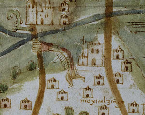
Glyph depicting the name-place of Mexicalzingo
The map that is the subject of discussion is thought to be the work of the noted Spanish cosmographer Alonso de Santa Cruz and it is one of only two known maps that give a fairly accurate picture of the city of Mexico and its surrounding regions in the mid 16th century. The map also gives information about the ethnography and the flora and fauna of the region. The population is shown performing a variety of activities, such as woodcutting, canoeing, hunting, and fishing.
The approximately 150 glyphs on the map, representing human and animal heads, feet, hands, circles and stars, refer to name places. These glyphs have, and continue to be a subject of investigation by scholars in the fields of art history, archaeologists, linguistics, and Mesoamerican studies, among others.
(Larsson, Díaz-Kommonen 2002, p. 492).
Among the objectives of the project has been the accurate transference of the representation of the Map in spite of radiometric and volumetric properties that, through the passage of time, have bestowed on the artifact an almost three-dimensional topography. Figure 2 depicts how such topography exists in the original Map of Mexico 1550 (Nuikka, Díaz-Kommonen, Haggren 2004).
2. Design of Digital Object
2.1 From Material object to digital facsimile
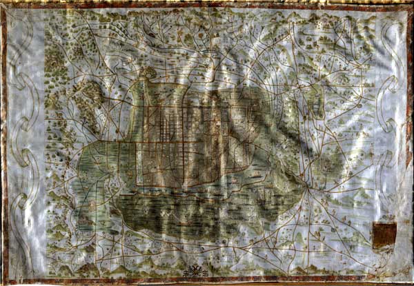
3D digital reconstruction of the Map of Mexico 1550. The image illustrates the topography found in the material artifact
The project to create the Digital Facsimile of the Map of Mexico 1550 has been realized as a collaborative endeavor between the University of Helsinki, Media Lab, the Helsinki University of Technology, Department of Photogrammetry, and the University of Uppsala Library, that is the keeper of the original item. The project, which started in 1997, continues to the present (Díaz 1998).
The artifact was created using similar photogrammetry techniques as in terrain mapping: the map was stereo-photographed and the shape of the parchment surface was measured from the images.
In order to get high-resolution images the map size of 114 cm x 78 cm was photographed in pieces, which were afterwards joined to an image mosaic. As the map surface was more likely a curved surface than a plane it was assumed that the images in a 2D mosaic would be distorted. Therefore the map was recorded with a stereo photography. Stereo images allowed a reconstruction of an elevation model of the map surface and when the model was defined, the geometric distortions caused by topography could be removed from the images before mosaicking.
The elevation model consisted of 3D coordinate points, spaced at 4 mm. By using these points, a triangular mesh was generated and the image mosaic was draped over it. A textured 3D surface model of the map was produced as a result of these procedures (Nuikka, Díaz-Kommonen, Haggren 2004).
2.2 Artifact design and digital facsimile
Artifacts are result and synthesis of human activity and directed action. In digital design, artifact is a 'place-holder' encompassing the internal structure of the item itself as well as the environment in which it operates (Díaz-Kommonen, Haggren 2006).
As an artifact, the Digital Facsimile denotes a digital representation of the original object of high quality, in terms of resolution, color, volume and shape accuracy
(Díaz 1998 and Díaz-Kommonen, Salgado 2003). It also provides an experience that would not be possible with the original without detriment to its integrity: the facsimile allows for extreme close-up examination and operates as an open system that can accommodate multiple discursive perspectives, or points of view.
Since its inception, the concept has focused on open, people-oriented, development that is platform independent. This has allowed the artifact to survive the tempests and storms prevalent in the Information Technology (IT) development cycles. Also, because the data is independent from the interface, it has been possible to develop diverse types of interfaces targeted to different audiences. Finally, the intensive data acquisition strategy presupposed for such a product also ensures that there will be enough for future generation products.
3. Interface Design
3.1 Interface design and exhibition of the Map of Mexico 1550
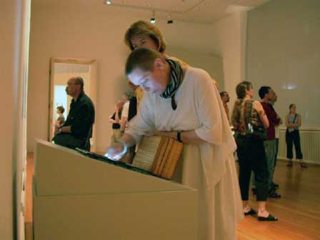
Digital Facsimile of the Map of Mexico at the Aztecs exhibition in the Martin-Gropius Bau Museum in Berlin
Modified versions of the interface have been created for each of these events. With each version of the interface, we have sought to create a good fit with the environmental conditions of each specific site.
The interactive application of Digital Facsimile participated, in lieu of the original, in the massive Aztecs exhibition held at the Royal Academy of Arts in London in 2002-2003. The facsimile traveled with the exhibition to its new venues first at the Martin-Gropius Bau in Berlin and then at the Kunst- und Ausstellungshalle der Bundesrepublik Deutschland in Bonn, Germany.
During September 2006 the Map was exhibited in the Media Lab Helsinki Campus exhibition at the Ars Electronica Festival in Linz, Austria. A new web-based interface designed around the capabilities of the ImaNote tool was used at this time. The installation also featured the use of a new interaction device. A 130.2 cm × 97.2 cm Smartboard allowed a single user to manipulate a large digital representation of the map. An additional projection system displayed the interaction of the user with the map to the audience in the exhibition hall.
In October 2006 the map is featured in Helsinki as part of The Two Faces of Mexico, an exhibition about Mexican culture at the Design Museum in Helsinki. This exhibition makes use of a very large projection of the Map to display the activity of a single user with the web-based application.
3.1.2 A stand-alone installation
The stand-alone installation was the first interactive tool created specifically for the Aztecs exhibition at the Royal Art Academy. It was designed as a single user application and employed a touch screen for both display and interaction.
This version displayed a 16,516 x 11,195 watermarked pixel map in which 64 x 64 tiles drawn in OpenGL, were used to manage the some 800 megabytes of data involved. Smaller versions of the map were included to enable smooth zooming between overview and detail views.
At this time, the foundation of an interactive structure for all subsequent versions was laid down. Such deep structure was built around the notion of navigation of information space via access to multiple levels of magnification. From the beginning we have employed a combination of touch screen and overview-zoomable interface (Hornbœck, Bederson, Plaisant 2002). The metaphor that informed the process was one of data being literally fed through the hand to the eye of the user.
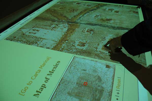
3.1.3 DisplayMap Tool and ImaNote
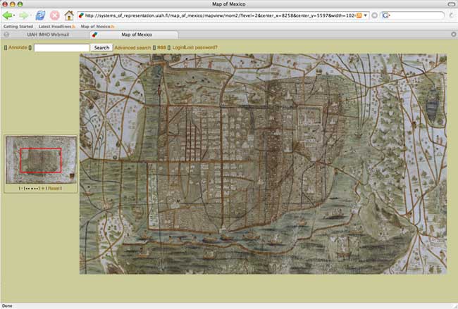
The Map of Mexico 1550 displayed using Image and Map Annotation Notebook software, ImaNote
Diverse variations of the interface have been developed, depending on the environment in which the Map is to be displayed. The task of porting the stand alone application into a new version delivered through the WWW began in the year 2004. The DisplayMap Tool was the first tool developed using such a strategy. The work at this point was informed by developments of the on-line map collections of the American Memory project at the Library of Congress in Washington D.C. Key differences, however, have been in the choice to develop Open Source software that is freely available and does not require the use of special plugins. Also, the new software still makes use of the overview-zoomable interface components for navigation.
During the Spring of 2005, the Systems of Representation (SysRep) group at Media Lab began working on ImaNote with the Learning Environments (LE) group. ImaNote (Imanote) is a generalized tool that can be used not only to display the Map of Mexico but also to annotate any map or image. Functionality now includes being able to add "notes" that are saved on the client-side. These notes display, among other things, text messages, links to multimedia resources on the web, and tags (or keywords). There is a search facility to locate notes according to tags entered and it is possible to load multiple images.
ImaNote can be used by a single person or, as social software, can be used by groups, or communities who desire to share and publish their content (Nuikka, Díaz-Kommonen, Haggren 2004).
3.2 Artifact, interface, and experience
Artifact is not the single object but rather a field of gathering. It brings together the substance, meaning, and structuring of human activity with the environment, or world, in which human agency unfolds.
The map can be experienced in a multitude of ways. In our research, initially the focus was on the individual experience of a single user such as a researcher. As the Map began touring in exhibition venues, the focus expanded to on both the individual and social experience in public settings, such as museums and gallery spaces as well as on networked environments like the WWW.
The individual experience can be public or private. In a public space, for example, a single user can be interacting with a version of the Map that only s/he can view.
The social experience can happen in several ways including physical as well as virtual public spaces. In a public space, there can be a single user interacting with a version of the map and this interaction can be displayed in multiple devices, such as for example, a large video screen. When there is more than one person in front of the map, the other persons who are not touching the screen might simply enjoy the sight, or actively give suggestions of how to use the application. In both of these cases, the viewers can be actively participating enjoying and navigating the map, with the rhythm of the one that is actively interacting (Díaz-Kommonen, Salgado 2003).
The social experience can be instantiated in the virtual domain, through the WWW. Using the ImaNote software that we have described, groups of people or communities who share an interest in the Map can create annotations and partake of their experience with the map.
4. Open Content Development
Like in a traditional facsimile, the design concept includes a Commentary (or Content) section that enables the user to deepen her knowledge about the artifact. In the Map of Mexico 1550 facsimile, the objective of this section is to also provide a needed "voice" to the visual artifact.
At the moment there is an anthology of legends containing a sample of seven legends that have been researched and re-interpreted using digital media. This work was done in collaboration with the program on Interactive Design at the Universidad Iberoamericana de Ciudad de México. This anthology of legends has been licensed using the Creative Commons license (Díaz-Kommonen 2005).
4.1 The chronicles and legends
Though it is expected that the content associated with the map will increase to include a growing corpus of historical material, at the moment, the initial narratives included focus in particular on the Chronicles and Legends pertaining to the historical center of the city.
Like myths, these Chronicles and Legends are stories that are partly based on historical truth and oral narratives. Through the passage of time, and with the interaction with other traditions, these narratives have become part of the collective consciousness of Mexican culture.
Some of them illustrate the existence and customs of the indigenous population of the city. Others narrate idiosyncratic events in the lives of the well-to-do Spanish elite. Of particular interest is the dramatic quality and how they are tied to the local urban spaces of the city. Through these aspects, they offer a possibility for alternative views of history to emerge. This networked, quasi-architectural narrative gathers a part of the soul of the city and it is worthy of study, exhibition, and preservation.
Conclusion
This essay provides an overview of the Digital Facsimile of the Map of Mexico 1550 project. The different stages, as well as some of the trans-disciplinary aspects of the process of designing and creating an artifact of digital cultural heritage are described. The objective has been to develop a design methodology for creating digital artifacts that enable documentation and reinterpretation of both tangible and intangible (or living) heritage.
* Nata in Porto Rico da genitori venezuelani, Lily Diaz-Kommonen insegna all'University of Art and Design di Helsinki e dirige il gruppo di ricerca Sistemi di rappresentazione presso il Media Lab della medesima Università. Nel 2002 ha pubblicato Art, Fact and Artifact Production, Ilmari Design Publications, Helsinki e ha ricevuto il premio Nabi Digital Storytelling, dall'Art Center Nabi di Seoul (Corea) e Unesco.
Lily Diaz-Kommonen
Professor, Systems of Representation
Media Lab
University of Art and Design Helsinki
135C Hämeentie SF 00560
Helsinki, Finland
diaz@uiah.fi
Sources
Díaz 1998
Lily Díaz, Digital Archaeology: Connecting Historical Narratives and Digital Environments, “Leonardo, Journal of the International Society for Art and Technology”, vol. 31, no. 4, The MIT Press, Cambridge (MA) 1998, pp. 283-287.
Díaz-Kommonen 2005
Lily Díaz-Kommonen, Digital Narrative and Collaborative Design in the Chronicles and Legends of the Historic Center of Mexico City. Design Perspectives, Envisioning Design for the 21st Century, Proceedings of the First International Conference held at the Universidad Iberoamericana de Ciudad de México, October 26-28, 2005.
Díaz-Kommonen, Haggren 2006 (forthcoming)
Lily Díaz-Kommonen, Henrik Haggren, Semantic Descriptions of Digital Surrogates, paper presented in the Symposium on Digital Semantic Content across Cultures, Paris, Louvre 4-5 May 2006 (forthcoming).
Díaz-Kommonen, Salgado 2003
Lily Díaz-Kommonen, Mariana Salgado, Interface Design and Usability Testing in the Digital Facsimile of the Map of Mexico 1550, in Discovering New Media, ed. by A. Botero e H. Rantavuo, Working Papers F26, University of Art and Design Helsinki, Helsinki 2003, pp. 16-21.
Hornbœck, Bederson, Plaisant 2002
K. Hornbœck, B. Bederson, C. Plaisant, Navigation Patterns and Usability of Zoomable User Interfaces with and without an Overview, ACM Transactions on Computer Human Interaction, vol. 9, no. 4, December 2002.
Imanote
ImaNote, distributed through Savanna.
Larsson, Díaz-Kommonen 2002
Lars-Olof Larsson, Lily Díaz-Kommonen, Catalogue Entries, in Aztecs, Thames & Hudson Ltd., London 2002.
Nuikka, Díaz-Kommonen, Haggren 2004
Milka Nuikka, Lily Díaz-Kommonen, Henrik Haggren, Photogrammetric Reproduction of the Map of Mexico 1550, in Proceedings of the XXth Congress of the International Society of Photogrammetry and Remote Sensing, Istanbul, Turkey 12-23 July 2004.
Alcuni siti di riferimento segnalati dall'autrice per informazioni relative a una selezione di leggende messicane e all'interessante Digital Library Project sulle Relaciones Geográficas de America.
English abstract
This essay provides an overview of the Digital Facsimile of the Map of Mexico 1550 project. The project to create the Digital Facsimile of the Map of Mexico 1550 has been realized as a collaborative endeavor between the University of Helsinki, Media Lab, the Helsinki University of Technology, Department of Photogrammetry, and the University of Uppsala Library, that is the keeper of the original item. The project, which started in 1997, continues to the present. The map that is the subject of discussion is thought to be the work of the noted Spanish cosmographer Alonso de Santa Cruz and it is one of only two known maps that give a fairly accurate picture of the city of Mexico and its surrounding regions in the mid 16th century. The map also gives information about the ethnography and the flora and fauna of the region.
Among the objectives of the project has been the accurate transference of the representation of the Map in spite of radiometric and volumetric properties that, through the passage of time, have bestowed on the artifact an almost three-dimensional topography.
The map can be experienced in a multitude of ways. In our research, initially the focus was on the individual experience of a single user such as a researcher. As the Map began touring in exhibition venues, the focus expanded to on both the individual and social experience in public settings, such as museums and gallery spaces as well as on networked environments like the www.
keywords | Luminar; Engramma; Internet; Humanism; Philology; Information; Map of Mexico 1550; Digital Facsimile; Alonso de Santa Cruz; Meico; University of Helsinki; the Helsinki University of Technology; University of Uppsala.
Per citare questo articolo / To cite this article: L. Dìaz-Kommonen, Designing and producing digital cultural heritage: the Mapo of Mexico 1550, “La Rivista di Engramma” n. 54, gennaio/febbraio 2007, pp. 15-25 | PDF of the article