Ancient history for tourism development
Building content for meaningful travel itineraries
Alessia Mariotti, Mattia Vitelli Casella
Abstract
Introduction: The European approach to culture and tourism
When it comes to cultural tourism studies, sustainability, and environmental protection are often addressed in the framework of the management of tourist flows accessing cultural attractions in urban areas. Before the pandemic, the main debate concerning cultural heritage attractions and sustainability was linked to the massive flows of tourists reaching historical city centers, thus endangering the social life of residents as well as the quality of their environment, without ensuring adequate economic impact on cities and regions. The phenomenon of over-tourism (maybe just a new name to refer to an old occurrence once called mass tourism) has been widely researched (Pechlaner, Innerhofer, Erschbamer 2019) and in some cases also compared or conceptually linked to under-tourism mainly characterizing peripheral and rural areas. The need to better balance tourism development and its capability to boost the multiplier effect on richness and job creation over European regions has been lately address by the EU Commission with specific background policies on tourism, where culture-based tourism and cultural routes have gained a paramount role because of their “remoteness and rural” geographical character (see Eu-Commission for Cultural tourism).
Cultural Routes have been a growing phenomenon starting from the launch of the program by the Council of Europe in the mid-1980s. Under a tourism perspective, these international cultural cooperation projects have been the forerunners of what is becoming nowadays a social habit: slow tourism and traveling, targeting social practices and culturally meaningful experiences. Identified as strategic, innovative, and creative tools for boosting social cohesion, thanks to their intrinsic cultural and political value, that Routes have also been a driver for local economic development based on sustainable tourism practices, inclusive cultural initiatives, and intercultural dialogue (Mariotti 2012; Azzari, Dallari 2018). Among the first certified Cultural Routes of the Council of Europe, pilgrimage trails have some peculiarities influencing their potential to act as local development drivers: they have a certain stability in time and space, the so-called geographical and historical sedimentation; they represent both short, medium and long networks of relationship among different actors; they are well embedded in their environment, contributing to shape cultural landscapes as well as civilizations and they could be interpreted as “living heritage” thanks to the constant interaction among visitors and guests. The continuous exchange between pilgrims and the local communities (Badone 2016) opens further possible research lines, aiming at unveiling the real contribution of these “formal and informal” tourism practices and experiences in addressing some of the crucial issues peripheral and rural areas are facing: the loss of population, the loss of services, economic and social marginalization. Nowadays pilgrims are voluntarily crossing borders, pushed by spiritual needs or by curiosity (Collings-Kreiner 2014). Independently from their first motivation, their transnational mobility action has an impact on local communities, as well as on their natural and social environment. Adopting Bourdin’s constructivist approach (Bourdin 2000), one could argue that places crossed by pilgrims have stronger development potential, due to the constant social construction, boosted by the collective action of both residents and pilgrims, repetitively negotiating the meanings of local identity.
Starting from the assumption that, so far, pilgrimage trails have had a limited environmental impact (Gupta 1999) and that this form of slow mobility is usually less interfering with the fragile equilibrium between humanity and its ecosystem, we argue that sustainability could be somehow also supported by driving hikers and bikers towards a deeper cultural discovery of the regions they are crossing. Furthermore, pilgrimage trails allow investigating sustainability also through different dimensions: the capability of local territorial systems to interact with upper-scale networks (as in transnational pilgrimage ways) thanks to diffused cooperation among different stakeholders: one of the rurAllure project premises and one of the standpoints of heritage-based itineraries development. The density of the network and the intensity of the relationships among the territorial actors, help in evaluating the capability of the mobility and cultural tourism practices along these routes to be sustainable, but also contribute building an upscaling analysis from local practices up to their effects over supranational territorial systems, where tourism is not a goal per se, but an implementation instrument for shared territorial projects. The latter is also one of the leading principles, supporting the aim and philosophy of the Cultural Routes of the Council of Europe program, where the role of cultural heritage is to enhance social cohesion through mobility and exchanges that heritage-led tourism can engage. As stated by Dallari (2018,50) “heritage is an important element for social identification”, because it combines both tangible and intangible elements: traditions, values, and beliefs, buildings, handicrafts, and landscape. The acknowledgment of a common heritage (in the sense that it is recognized as such by all Europeans) thanks to tourism and slow mobility along and in the vicinity of pilgrimage ways, not only paves the pace for respectful visiting practices but brings also to the surface the role of ancient history in sustainable development. As stated by the Council of Europe in the Santiago Declaration in 1987: “That cultural identity has been and still is made possible by the existence of a European space bearing a collective memory and crisscrossed by roads and paths which overcome distances, frontiers, and language barriers”.
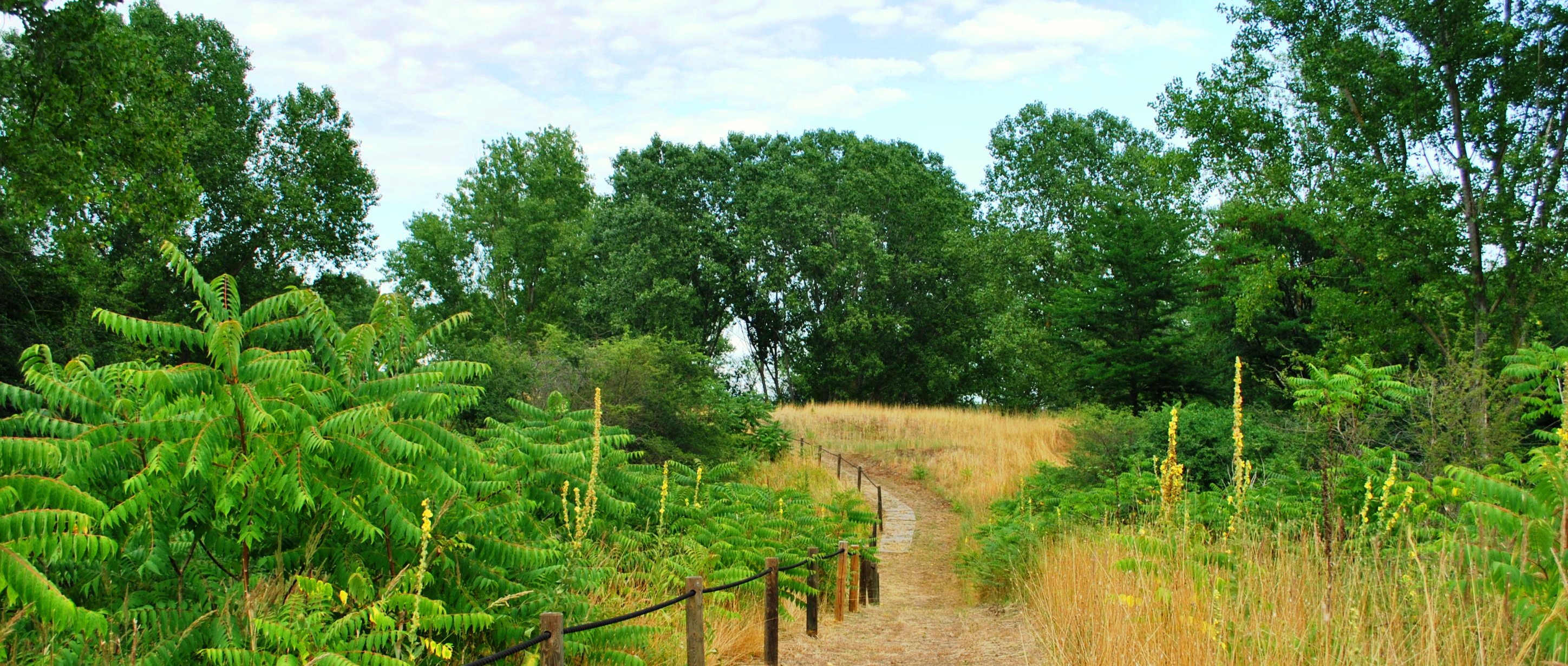
In the following paragraph, we present some reflections on the possibility for regions crossed by linear slow mobility infrastructures such as the pilgrimage ways labeled by the Council of Europe, to develop new tourism products coupling sustainability with the need of rebalancing the visitor’s flows towards less frequented rural areas. Starting from one of the stops of the Via Romea Germanica in Emilia-Romagna, an alternative path suitable for bikes and rich in meaningful cultural heritage contents is presented.
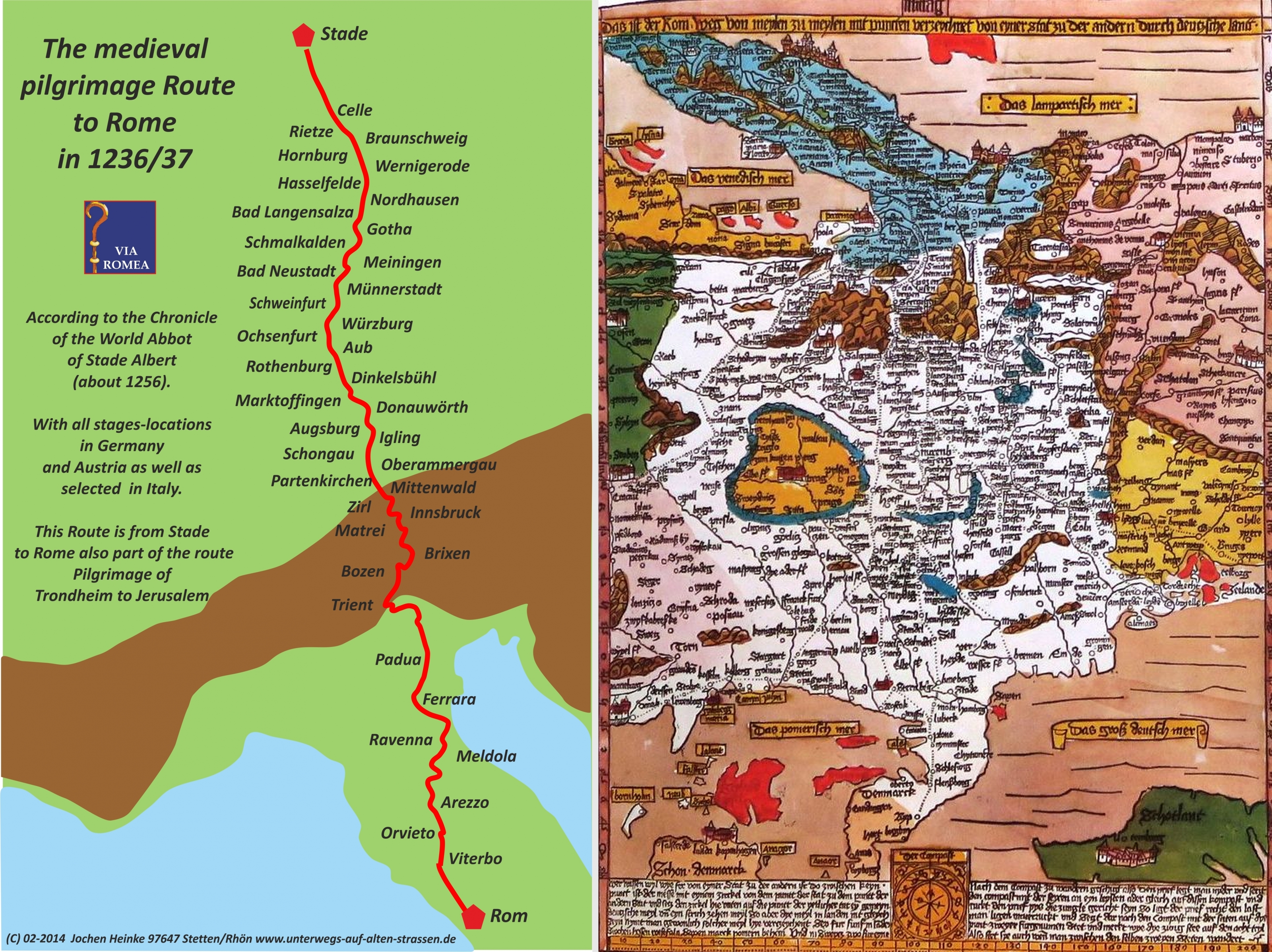
1 | Map of the Via Romea Germanica (by Jochen Heinke);
I. Ancient history-based bike itineraries in the vicinity of Via Romea Germanica
How to combine environmentally friendly tourism and ancient cultural heritage? The question does not bring us to an unexplored field because sustainable cultural tourism is now a widely spread reality throughout Europe, encouraged by the European Commission in different ways, with many actions and funded projects (see for instance the website Eu-Comission for Sustainable Cultural Tourism) with links for further information). As stated above, within this framework, special attention is paid to cultural and historical routes rediscovered or recreated based on common elements for towns and countries. One of the strong points of this initiative is to promote tourism in lesser-known regions, for exploiting the growth potential of small towns’ cultural heritage. In this context, there are several projects concerning meaningful itineraries of the Roman age and late antiquity, now to be covered on foot or by bicycle. Keeping our focus on the Adriatic coast (Turchetto 2021), we can mention examples of Roman roads via Annia or via Claudia Augusta, and examples of early pilgrims' way Via Francigena, recognized in 1994 as Cultural Route of the Council of Europe and in 2019 extended from Rome to Santa Maria di Leuca, based on the Itinerarium Burdigalense (see the website of Eu-Commission for European cultural Routes), one of the most relevant ancient itineraries dating back to 333 AD. Even if these cases are very different from one another, they have a coherent axis based either on the Roman network of roads and settlements or on a historical fil-rouge, as a famous person and his journeys. This is the concept also underpinning the Via Romea Germanica, which in some stretches follows Roman roads and to which, in the German-speaking countries, the well-rooted green awareness has granted success as travel infrastructure by bike or on foot.
For the present case study, we have established an alternative route according to contemporary needs, as explained in detail in other contributions of this volume, therefore we do not have any ancient path to follow like the ones mentioned until now, but the choice of relevant elements of cultural heritage along the established route has been strongly influenced by the availability of safe routes for bikers or walkers. We aim to provide visitors with a wide range of tangible and intangible cultural heritage assets to be experienced at a slow pace, and it is self-evident that this kind of practice gives travellers the time and opportunity to better understand the territories and cultures crossed by the selected route. The resulting green-friendly touristic offer allows us to appreciate the environment around the paths as well as the cultural heritage located in rural areas far from the most popular tourist routes.
Our first goal would be to give the travellers along this pilgrimage path an idea of how the landscape, in its broadest sense, changed and was modelled through the centuries by the interaction between men and nature. The concept behind that is that cultural heritage, in this case, the ancient one makes more sense if it is appreciated in its natural environment, in other words in what is commonly defined within a holistic approach to a cultural landscape. Such a point of view is stressed several times in the current National Research Programme (PNR) 2021/2027, especially in the research and innovation area entitled “Humanistic Culture, Creativity, Social Transformations, Society of Inclusion”. Within it, three intervention areas – Cultural Heritage, Arts, History and Literature, and Ancient History – have specific research lines devoted to the match between humanities and green transition (PNR 2021/2027, 58-59, 61-62, 65-66). Indeed, in a few places the natural conditions were as decisive as in the Po Delta for influencing in every age both human settlement and activities, which on their side preserved the environment. It is in this perspective of a persistent relationship between men and nature, even though applied to the Renaissance and the Este dynasty, that the Po Delta was included in the Unesco world heritage list. The criterion is worth quoting: “The Po Delta is an outstanding planned cultural landscape that retains its original form to a remarkable extent”. These words perfectly fit our goal and could be a reference also for the Roman time, although unfortunately, the traces regarding the monuments as well as the countryside planning are scarcer.
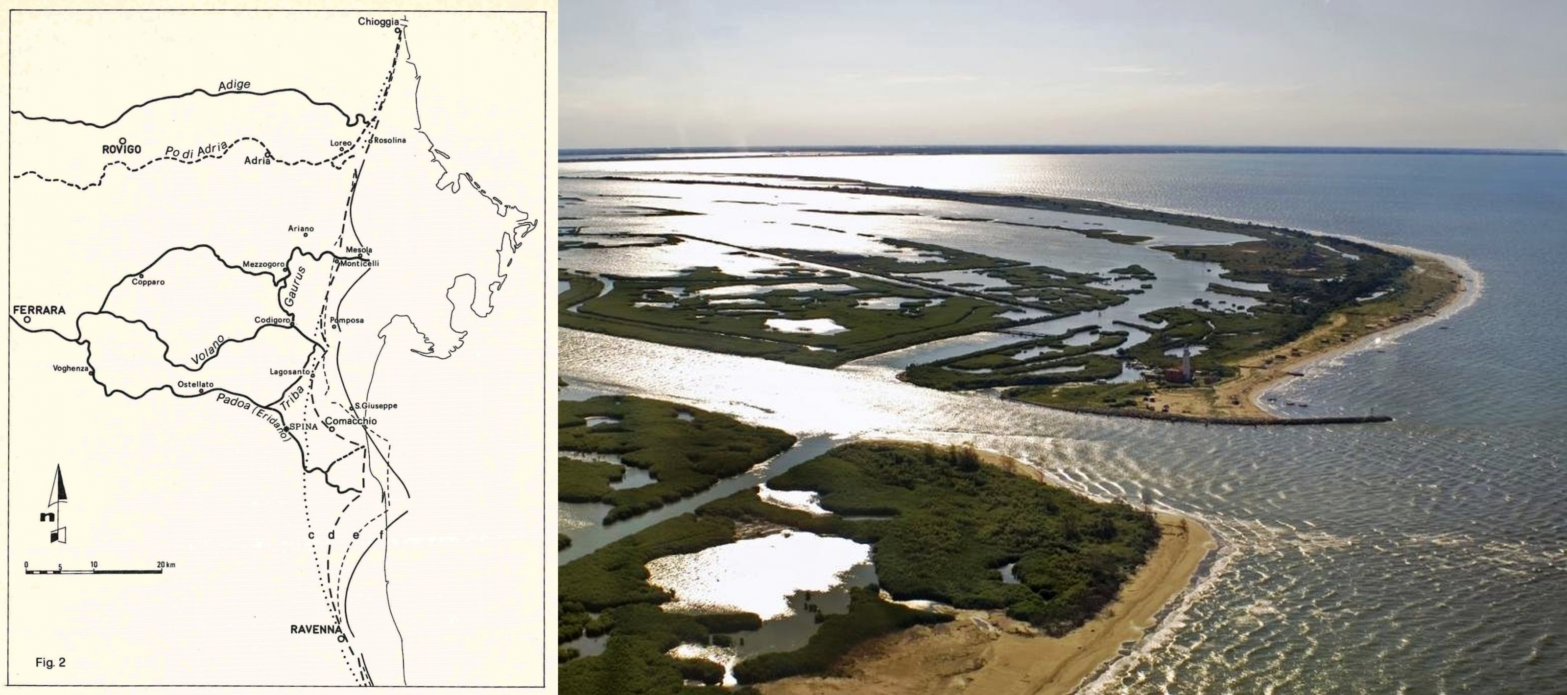
2 | Reconstruction of the ancient Po Delta with the evolution of the coastal line between Etruscan and Medieval Ages.
Lines: c) IV century BC; d) II century BC; II century AD; f) VI-VII century AD (from Bondesan 1986); an aereal view of the Po Delta coastal line today (©CC).
I.1. The Po Delta: an ideal combination of ancient history and nature
Ancient geography: In this regard, we must consider that the physical geography of this part of the Po basin consistently changed from antiquity until now, due to the modifications of the path of the rivers, above all that of the branches of the Po Delta. Many scholars have attempted to the reconstruction of the ancient geography of this area through the analysis of literary sources, such as Polybius and Pliny the Elder (Plb. II 16.10-12; Plin. nat. III 119-122), and geomorphological data (Ciabatti 1966; Bondesan 1986; Bondesan 1990; Cremonini 2022). The environment, together with human intervention, already in antiquity created different and peculiar landscapes. As a further example, in ancient northern Italy, a turning point under this point of view was undoubtedly the moment when Romans organized the settlement upon the colonization of Cispadane Gaul and reclaimed the land as preliminary action for allotting cultivable fields to the colons through the centuriation. This process usually left the most durable traces of the Roman intervention in the countryside and in this case can be considered a parallel of the above-mentioned initiative of the Este family in the surroundings of Ferrara. Unfortunately, such traces are not visible on the southern side of the present-day course of the Po (Cremonini 2022, 77-80); the impact on landscape of the Roman conquest in this region is quite uncertain and probably limited, because here the Romans adapted to the environmental conditions more than elsewhere, due to the lack of experience with such terrains (Uggeri 1986, 167-171). On the contrary, on the northern bank, the grid in the Adria’s ager is not only still recognizable (Zerbinati 1984, 150-151) but has also been the object of musealisation and tourist valorization in Villadose, which also includes some cycling and walking paths in the countryside aiming at directly discovering this ancient landscape (see the website of Museo della Centuriazione ).
Cultural and natural heritage: After these preliminary words, let us move to the description of the designed route and the explanation of the reasons behind it. The aim is to offer bike tourists the possibility of a nature-immersive experience in the Po Delta Park, one of the most important wetlands in Europe and the largest in Italy, which obtained an award from Unesco also as biosphere reserve (see the Po Delta website/Biosphere). The Park extends over two provinces (Ferrara and Ravenna) of the region Emilia-Romagna and the province of Rovigo in Veneto. The Park area as whole could be interpreted as a large eco-museum aiming at “research, conservation, protection, and enhancement of a set of cultural assets, of both a tangible and an intangible nature” (see the Po Delta website/Ecomuseum). It stages environment, landscape, territory, and the ways of life that have followed and accompanied its development. The Park is an inhabited protected area, therefore much valuable because of the active participation of the local communities, the so-called heritage communities mentioned by the Faro Convention. The Faro Convention spirit, even though addressing specifically cultural heritage, can be applied to natural heritage as well. By cycling or walking in this exceptionally preserved environment, we aim obviously at bringing the tourists to discover the ancient cultural heritage, which has been deeply investigated by scholars (nota 9: for instance, Civiltà comacchiese 1986; Alfieri 1989; Uggeri 2006; Berti et alii 2007) but has been for a long time undervalued by the tourism sector and is therefore still less known to the public. The best example of this approach is the Etruscan town of Spina, a multi-ethnic emporium of antiquity, exceptional in the northern Adriatic, which was discovered and excavated for the first time in 1922. Fortunately, excavations and scientific research continued (for instance, Patitucci, Uggeri 2016-2017; Reusser 2017; Uggeri 2020; Buoite et alii 2022), but the site is not accessible for visitors as a proper archaeological area. As we will see in the following lines about San Basilio and Comacchio, the awareness of this topic has increased over the last years thanks to innovative museum concepts and projects, whose mission is to recreate the ancient landscape for an immersive visit experience. To enhance knowledge and accessibility to cultural heritage, the Delta Park has developed a few weeks ago (May 2023) a section on its website dedicated to archaeology. Among the many valuable outputs of this initiative, the most relevant for our purposes is the interactive and georeferenced map of the archaeological and cultural heritage sites. Even though it is not a complete archaeologic map, still it is an exhaustive smart guide for both tour operators and tourists who want to plan their tour autonomously (see the Po Delta website/Archaeological detour). Besides witnessing the enhanced attention on this topic, it is worth noticing that the adopted approach, combining natural and cultural heritage, is in line with the above-mentioned holistic concept of landscape. Our attempt here is to couple the already available slow mobility facilities with an ancient history fil rouge, thus allowing visitors to move sustainably across the region while experiencing its history first-hand and the ancient landscape in its different fundamental elements.
A bike-friendly territory: The route we propose in this paper reaches the vicinity of Ravenna, but it is included within the ancient Po Delta. It was more extended southwards in comparison with today’s situation. From the administrative point of view, the itinerary is quite completely within the Po Delta Park borders and within the Province of Ferrara, which paid in the last years great attention to bike tourism, developing a broad network of cycling routes with services dedicated to bike lovers, with information easily accessible through the web. As for the task of designing the itinerary, a fundamental tool has been the Bike Book downloadable from the Official Tourist Information Site of the province, because it provides detailed practical information on each trail, such as maps, length, difficulty, path or road surface, bike-friendly accommodation facilities, in addition to some tips for visits and experiences.
I.2 The itinerary
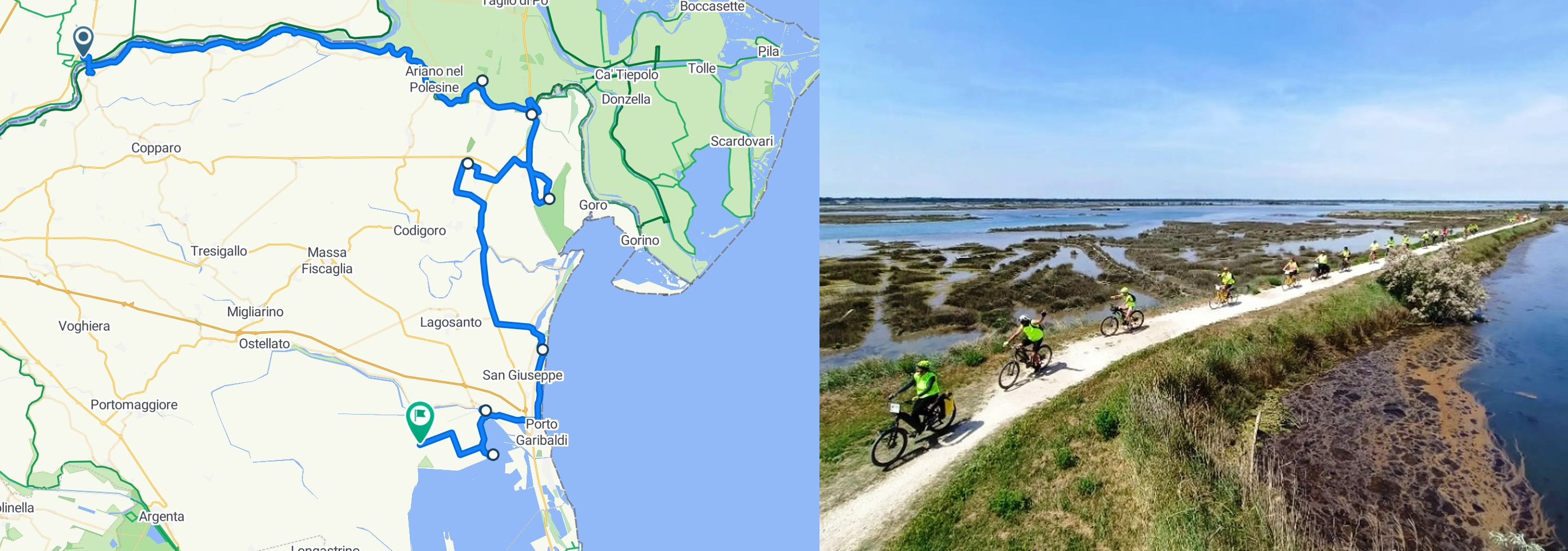
3 | The proposed itinerary for bike tourists (elaborated from www.bikemap.net/). A bike journey in the Po Delta Park (©CC).
I.2.a.
The detour diverges from the route of the Via Romea Germanica at the crossing of Polesella; after the bridge, we will follow on the Emilian side of the Po for 34,5 km the Destra Po cycle path, section of the EuroVelo 8 – Mediterranean Route, up to Ariano Ferrarese, where we will cross the Po di Goro, its southernmost branch, to reach the archaeological site of San Basilio (Ariano nel Polesine, Rovigo). It is located on the so-called Isle of Ariano because it is surrounded by river branches. Besides its peculiar landscape, it is an important archaeological site with several habitation stages. Its first phase was that of a flourishing ‘international’ port-emporium, like the more famous Spina, dating back to the VI century BC. It was inhabited mostly by Etruscans with minor presence of Greeks and Venetians and benefitted from its geographical position (Negrelli et alii 2013; Gambacurta 2014; Iadicicco et alii 2022, 53-56): indeed, as we will see better with regard to Massenzatica, it rose close to the coastal dune belt IIa according to the classification of Ciabatti (Ciabatti 1966), and on the Po di Ariano near to the mouth. In the light of this favourable position, it developed as relevant harbour and exchange place between the Po Plain and the Adriatic routes before the growth of Adria. After a decline stage or even an abandonment, a Roman minor settlement grew along the via Popilia/Annia, the road connecting Ravenna and Altinum, and should be identified with the mansio (vicus according to some scholars) Hadriani mentioned in the Tabula Peutingeriana (TP IV 1; Uggeri 1989, 119-120; Uggeri 2012, 155; Negrelli et alii 2013, 78; Cremonini 2022, 76). It was continuously inhabited in Late antiquity with an early Christian complex and later in Early Middle-Ages, as attested by the Romanesque church. It emerges already from these few words that the history of the site is very interesting, and its cultural heritage is rich and accessible to many target groups. In fact, the major evidence of the Roman settlement consists in a building usually called villa, but probably to be seen as a mansio connected to the road, and another building, interpreted as a horreum (II-III century AD) beside the early Christian complex, one of the oldest in the region (IV century AD). What is particularly relevant for our purpose is to underline that there is an archaeologic visitable area including the necropolis and the early Christian complex (see the website for St. Basilio in Ariano/Archaeological area), close to the museum. It has an exhibition conceived in an innovative way to bring visitors into the ambiance, characterized by the settlement, the road, the river, the sea, and their interconnections, and their changes for a long timelapse, from Late Bronze Age to Early Middle Ages (see the website or St. Basilio in Ariano/Cultural center; Facchi et al. 2022, 208-210). Among the archaeological pieces, there are also two Roman inscribed monuments, a stele of the type called ‘a disco’, dating back between the end of the I century BC and the beginning of the I century AD (Zerbinati 1984, 150), and a later sarcophagus of the II-III century AD, yet unpublished, as to our knowledge. In the context of the exhibition, they are valuable witnesses of the ancient society bearing names of inhabitants and information about their life: for instance, the marble sarcophagus is a type of monument widely attested in the ancient Po Delta but chosen by families having good means (Rebecchi 1986, 136-145).
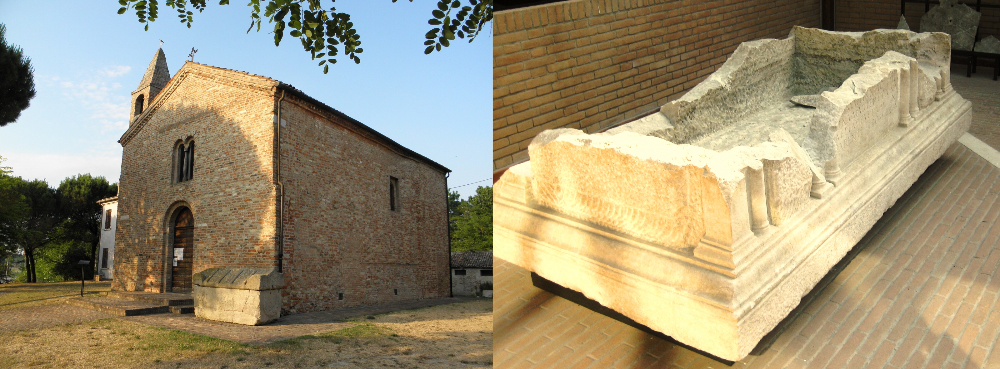
4 | Romanesque church of S. Basilio, IX c. AD, Ariano nel Polesine; Roman sarcophagus, II-III c. AD, from the archeological area of S. Basilio, Ariano nel Polesine, kept in the local Cultural center (Photos: Parco Regionale Veneto del Delta del Po).
I.2.b.
After the visit to San Basilio, we will proceed for a few km on the path over the northern bank of the Po di Goro. After crossing it in Mesola (the center of the Natural Park), we will join the guided excursions in a particular reserve area called Boscone della Mesola (Great Mesola Wood). This is an outstanding example of biodiversity and one of the largest and best-preserved remains of the forest broadly diffused on the northern Adriatic coast in the past (Uggeri 1989, 14). The wood is still frequented by bird species, which usually do not frequent anymore in this environment, and by native dune deer. As for the ancient landscape, the Fossil Dunes of Massenzatica Reserve, on the other side of the National Route 309, is worth visiting for the goal of this itinerary (see the website of Po Delta/Parks and Natural reserves). These dunes, already mentioned about San Basilio, formed still in the Bronze Age along the shoreline and they are valuable for establishing the coastlines during the centuries (Ciabatti 1966; Bondesan 1990, 16). Unfortunately, as many other traces of nature in antiquity, they have been often obliterated and therefore this site is particularly valuable under this point of view. Indeed, Massenzatica and San Basilio are located on the same dune line IIa according to the classification of Ciabatti (Ciabatti 1966, 383-384) and now are separated only by the Po di Goro, allowing the visitors to appreciate the continuity or changes in the landscape of this area. The context should have been not so different in antiquity, because the Roman settlement in present-day Massenzatica and that of San Basilio were on the opposite banks of the Olana/e along the via Popilia/Annia, which crossed the river, with a bridge or by boat (Uggeri 2012, 153-155). Both settlements were situated on the same coastal dune belt, on which also the main road was traced in the Late Republic; this became a fundamental element of the ‘new’ Roman landscape, as attested also by a milestone found around 10 km southernly in Ponte Maodino (Codigoro), always on the same dune line (AE 2009, 393; Donati 2009; Uggeri 2012, 137-140).
6 | Fossil dunes in Massenzatica of the Bronze Age. Photo Archivio fotografico Provincia di Ferrara.
I.2.c.
The last asset of our tour is reachable by a stretch of the Adriabike route, which 25 km leads us from the Massenzatica Reserve to Comacchio, the most important town in the Delta. In addition to the high value of the historical city center, it houses the newly opened Ancient Delta Museum. Thanks to modern technologies, scenography, and reconstructions of contexts and even olfactory paths, it leads the visitor most appropriately not only to appreciate beautiful objects but rather to experience the entire ancient territory and its inhabitants. In light of our focus, attention will mainly be paid to the Etruscan and Roman sections, the first dedicated to the already mentioned Spina, the second showcasing the exceptional discovery of the wreck of Valle Ponti, a Roman ship with perfectly preserved cargo dating back to the end of the I century BC (Berti 1990). Its relevance consists of course in the rarity of such findings but even more in the type of the ware, like shoes, wood items, and other personal belongings, which accompany the visitors into the life of their ancient owners (see the Ancient Delta Museum website/Roman ship). The museum has also an open-air section, located in Stazione Foce, on the western bank of the Valli di Comacchio, a few kilometres inland. The place is easily reachable with a panoramic cycle path along the Valli and is near the actual site of Spina. The museum is the result of a long project of experimental archaeology conceived for ‘rebuilding’ the ancient emporium; this has been done as precise as possible to provide the visitors with a view over a landscape similar to the one an ancient merchant, Etruscan, or Greek saw in Spina. Of course, this section of the museum makes sense if combined with the section of the ‘traditional’ museum dedicated to the findings from Spina, above all the exceptional collection of Attic vases, testifying the rich emporium reality of that town. Not far from Stazione Foce is the late-antique archaeologic complex of Santa Maria in Padovetere, located on the major branch of the Po in the Etruscan period, called Eridanus or Po di Spina, which deactivated in the VI century when the monasterium was built (Cremonini 2022, 81-82). The site is centred on a church and a baptistery, but the excavations of that area have discovered other structures and some material witnessing an earlier occupation stage, to be interpreted as a minor settlement of the Roman imperial age continuously inhabited, where the monasterium was built under the Goths and then replaced by a new one during the Byzantine period (Corti 2007; Cesarano, Corti 2017. This does not surprise, because there were several small-sized settlements and villae along the main coastal road (Uggeri 1989, 69-77). Unfortunately, the site of Santa Maria in Padovetere is usually not accessible, while it would be very meaningful for giving the visitors the idea of human occupation continuity of a settlement till the Early-Middle Ages, as in San Basilio. Moreover, the archaeological potential of the area is high, as attested by the recent discovery of three late antique ships (Cesarano, Corti 2017, 353-357).
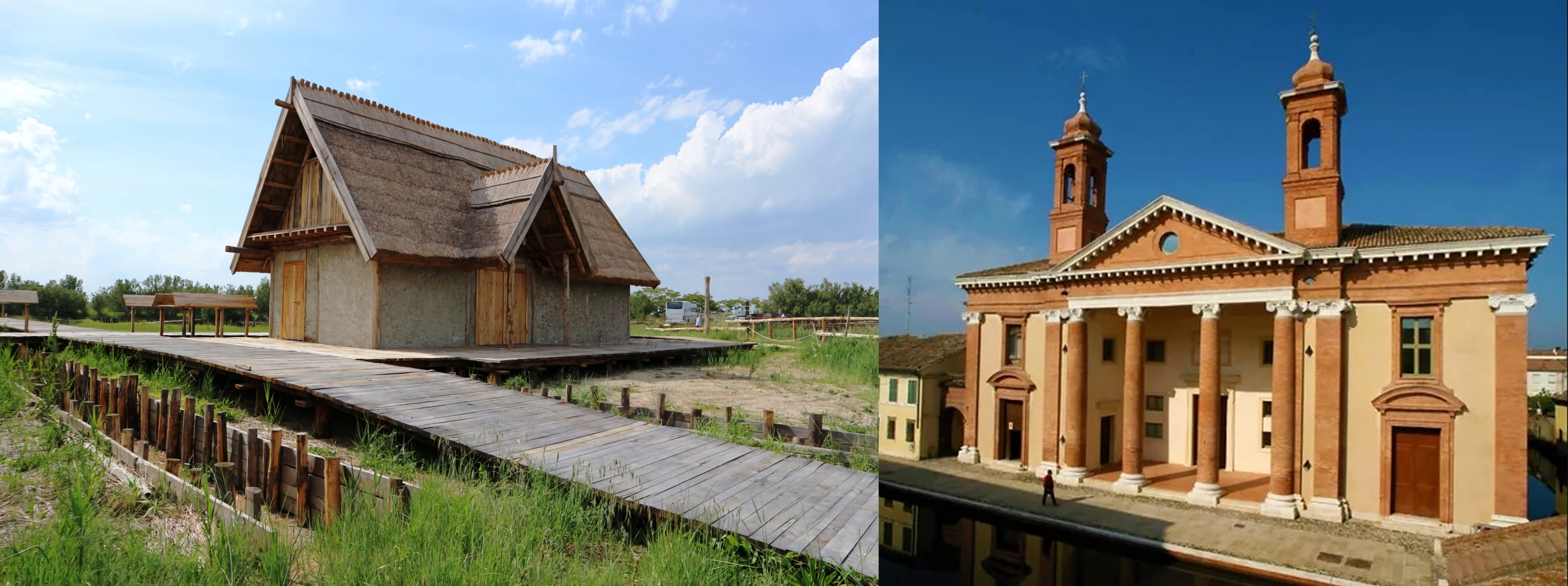
7 | Hypothetical reconstruction of the ancient Spina, in the open-air section of the Museo del Delta Antico, and the Museum in Comacchio. Photo: Archivio di Delta Po Tourism.
II. Meaningful travel itineraries and sustainability at work: the rurAllure project
As already stated in the introduction, with this short essay we intended to underline the possibility to strengthen the relationship between ancient history and slow tourism in the vicinity of established pilgrimage paths, by emphasizing the need to integrate sustainability (both environmental and social) into the planning phase of tourist experiences. The research framework and context, rurAllure, an H2020 project for the development of a cooperation and support action enhancing the networking capabilities of small rural museums and heritage sites in the vicinity of transnational pilgrimage routes (see more details in other articles within this special issue), has allowed us to imagine how to cope contemporary bike tourism needs with meaningful cultural content. Pilgrimage and in general walking tourism are expanding sectors, with increasing demand for services along the routes. In some cases, when the slow tourism infrastructure is well developed and maintained, these linear cultural routes become important local development magnifiers, possibly impacting the economic opportunities for the populations of the crossed regions. Depending on the stage in the lifecycle of the pilgrimage route, its development potential might be hindered by over-tourism side effects (as on the last stage of the Santiago Pilgrimage way) or, on the contrary, by little frequentation rates lowering the interest for public and private stakeholders’ engagement. For resident communities, the benefits of pilgrimage trails reside in the economic impact they can ensure locally, mainly through accommodation.
The assumption underpinning the rurAllure project approach is that a wider area in the vicinity of the pilgrimage way could benefit from it if new products and cultural experience opportunities are designed and implemented, able to lure walking tourism passionate and let them stay longer to discover the surroundings also using other slow tourism travel means. To demonstrate the benefits and potentials related to the proximity of pilgrimage trails, we have designed a possible alternative itinerary by bike, starting from one of the stages of the Via Romea Germanica in the Ferrara province (Italy). Bike tourism infrastructures have gained a strategic role in this specific area of the region and some of the bikeable itineraries overlap ancient Roman roads or the pilgrimage way itself, thus facilitating the development of a slow cultural tourism option for hikers or pilgrims looking for enriching their experience while on the road. Ancient history has been used as a fil rouge not only to design a featured trip in the proximity of Via Romea Germanica but also to underline the role of cooperation and networking among stakeholders of both tourism (for instance bike rentals) and the culture and museums services. The area is rich in archeological sites and in ancient settlements that just need to be coordinated as a single product with themed offerings.
To conclude, the resulting green-friendly touristic offer allows us to appreciate the environment around the paths as well as the cultural heritage located in rural areas, far from the most popular tourist routes, thus contributing to lowering tourism pressure on highly frequented destinations (in our case the province capital cities Ferrara and Ravenna). Furthermore, the chosen theme around ancient history and related cultural landscape, calls for increasing research and transfer of knowledge on the iconic identity traits of this territory (the Po Delta area). Finally, we argue that through this exercise we have operated accordingly to the main role of a certified Cultural Route of the Council of Europe (CM/Res(2013)66):
[…] shall contribute to reinforcing the potential of […] cultural co-operation, sustainable territorial development, and social cohesion, with a particular focus on themes of symbolic importance for European unity, history, culture, and values and the discovery of less well-known destinations. It shall strengthen the democratic dimension of cultural exchange and tourism through the involvement of grassroots networks and associations, local and regional authorities, universities, and professional organizations. It shall contribute to the preservation of a diverse heritage through theme-based and alternative tourist itineraries and cultural projects.
Bibliographical references
- Azzari, Dallari 2018
M. Azzari, F. Dallari, Le Vie Romee dell'Europa e del Mediterraneo di viandanti, pellegrini e mercanti. Le strade dell'identità europea nelle pratiche contemporanee, in F. Salvatore (ed.), L’apporto della Geografia tra rivoluzioni e riforme, Roma 2018, 995-944. - Alfieri 1989
N. Alfieri (a cura di), Stora di Ferrara, vol. III:l’età antica, II. IV a.C.-VI d.C., Ferrara 1989. - Azzari, Dallari 2018
M. Azzari, F. Dallari, Le Vie Romee dell'Europa e del Mediterraneo di viandanti, pellegrini e mercanti. Le strade dell'identità europea nelle pratiche contemporanee, in F. Salvatore (ed.), L’apporto della Geografia tra rivoluzioni e riforme, Roma 2018, 995-944. - Badone 2016
E. Badone, Conventional and Unconventional Pilgrimages: Conceptualizing Sacred Travel in the Twenty-first Century, in A.M. Pazos (ed.), Redefining Pilgrimage. New Perspectives on Historical and Contemporary Pilgrimages, Burlington 2016, 7-31 - Berti 1990
F. Berti (ed.), Fortuna maris. La nave romana di Comacchio, Bologna 1990. - Berti et alii 2007
F. Berti, M. Bollini, S. Gelichi, J. Ortalli (a cura di), Genti nel delta da Spina a Comacchio: uomini, territorio e culto dall'antichità all'alto Medioevo, Ferrara 2007. - Bondesan 1986
M. Bondesan, Lineamenti di geomorfologia del basso ferrarese, in Civiltà comacchiese 1986, 17-28. - Bondesan 1990
M. Bondesan, L’area deltizia padana: caratteri geografici e geomorfologici, in Il Parco del delta del Po: studi e immagini. L’ambiente come risorsa, Ferrara 1990, 9-40. - Bourdin 2000
A. Bourdin, La question locale, Paris 2000. - Buoite et alii 2022
C. Buoite, M. Cremaschi, L. Malnati, L. Zamboni, Delenda Spina. Trasformazioni del delta del Po in epoca ellenistica, in R. Perna, R. Carmenati, M. Giuliodori (eds.), Roma e il mondo adriatico. Dalla ricerca archeologica alla pianificazione del territorio, vol. II.1 Adriatico centro-settentrionale e orientale, Atti del Convegno Internazionale (Macerata, 18-20 maggio 2017), Roma 2022, 291-309. - Cesano, Corti 2017
M. Cesano, C. Corti, Sacro e profano. Le recenti ricerche nell’area archeologica di S. Maria in Padovetere a Comacchio (IV-IX secolo), in C. Ebanista, M. Rotili (eds.), Dalle steppe al Mediterraneo. Popoli, culture, integrazioni, in Fondazioni e rituali funerari delle aristocrazie germaniche nel contesto mediterraneo, Atti del Convegno Internazionale (Cimitile.S. Maria di Capua Vetere, 18-19 giugno 2015); Oriente e Occidente fra tarda antichità e medioevo, popoli e culture dalle steppe al Mediterraneo, Atti del Convegno Internazionale (Cimitile.S. Maria di Capua Vetere, 16-17 giugno 2016), Napoli 2017, 351-369. - Ciabatti 1966
M. Ciabatti, Ricerche sull’evoluzionoe del delta padano, “Giornale di geologia” 34, 2 (1966), 381-340. - Civiltà comacchiese1986
La civiltà comacchiese e pomposiana dalle origini preistoriche al tardo medioevo, Atti del Convegno Nazionale di studi storici (Comacchio 1984), Bologna 1986. - Collings-Kreiner 2014
N. Collings-Kreiner, Pilgrimage and Mobilities: The “pilgrimage Turn” within the “New Mobilities Paradigm”, in R.C.L. Gonzáles, X.M. Santos-Solla, and P. Taboada-de-Zuñiga (eds.), New Tourism in the 21stCentury: Culture, the City, Nature, and Spirituality, Newcastle upon Tyne2014, 33-54. - Corti 2007
C. Corti, Santa Maria in Padovetere: la chiesa, la necropoli e l’insediamento circostante, in Berti et alii 2007, 531-552. - Cremonini 2022
S. Cremonini, Problematiche geomorfologiche relative all’evoluzione paleoidrografica padana predeltizia di età tardoantica (V-VII sec d.C.), in M. Buora, S. Magnani, L. Villa (a cura di), Italia settentrionale e regioni dell’arco alpino tra V e Vi secolo d.C., Atti del convegno (15-17 aprile 2021), Trieste 2022, 69-96. - Dallari 2018
F. Dallari, Cultural itineraries and Roman routes: challenges and opportunities for sustainable local development and social participation, in H. Porfyriou, Y. Bing (eds.), China and Italy: Routes of Culture, Valorisation and Management, Roma 2018, 36-45. - Donati 2009
A. Donati, T. Annius T.F., “Epigraphica” 71 (2009), 73-83. - Facchi et alii 2022
A. Facchi, F. Barion, G. Falezza, G. Gambacurta, S. Paltineri, M.C. Vallicelli, Delta del Po (RO). Progetti di valorizzazione in corso, “Archeologia del Veneto 2015-2019. Notiziario delle Soprintendenze” (2022), 205-210. - Gambacurta 2014
G. Gambacurta, L’insediamento antico di San Basilio di Ariano nel Polesine, in Dalla catalogazione alla promozione dei beni archeologici. I progetti europei come occasione di valorizzazione del patrimonio culturale veneto, Venezia 2014, 305-308. - Gupta 1999
V. Gupta, Sustainable tourism: learning from Indian religious “International Journal of Contemporary Hospitality Management” 11, 2/3 (1999), 91-95. - Iadicicco et alii 2022
G. Iadicicco, D. Vincenzutto, S. Paltineri, Cluster analysis, classificazione nuerica e remote sensing. Metodi di analisi integrati applicati alla survey presso san Basilio di Arriano Polesine (RO), “Archeologia e calcolatori” 33, 2 (2022), 53-76. - Mariotti 2012
A. Mariotti, Local System, Networks and International Competitiveness: from Cultural Heritage to Cultural Routes, “Alma Tourism” 3/5 (2012), 81-95. - Negrelli et alii 2013
C. Negrelli, T. Abbà, A. Ninfo, P. Mozzi,San Basilio di Ariano Polesine, in Archeologia e paesaggio nell’area costiera veneta: conoscenza, partecipazione e valorizzazione, Venezia 2013, 76-84. - Patitucci, Uggeri 2016-2017
S. Patitucci, G. Uggeri, Spina. Topografia, urbanistica, edilizia: un aggiornamento, “Atti dell’Accademia delle scienze di Ferrara” 94 (2016-2017), 181-219. - Pechlaner, Innerhofer, Erschbamer 2019
H. Pechlaner, E. Innerhofer, G. Erschbamer (eds.), Overtourism: Tourism management and solutions, London 2019. - Rebecchi 1986
F. Rebecchi, La romanizzazione del basso ferrarese: aspetti artistici, in Civiltà comacchiese 1986, 113-146. - Reusser 2017
C. Reusser (hrsg.), Spina. Neue Perspektiven der archäologischen Erforschung, Tagung an der Universität Zürich (4-5 Mai 2012), Rahden 2017. - Turchetto 2021
J. Turchetto, Dai punti alla linea, dalla linea alla rete: lo slow tourism lungo le antiche vie dell’Adriatico, dal Po alle isole Incoronate, in B. Castiglioni, M. Puttilli, M. Tanca (eds.), Oltre la convenzione. Pensare, studiare, costruire il paesaggio vnt’anni dopo, Firenze 2021, 137-150. - Uggeri 2006
G. Uggeri, Carta Archeologica del Territorio Ferrarese (F.° 77 III S.E.), Comacchio, Galatina 2006. - Uggeri 2012
G. Uggeri, La nuova Via Annia da Roma ad Aquileia (153 a.C.), “Journal of ancient topography” 22 (2012), 133-174. - Uggeri 2020
G. Uggeri, Spina in età romana, “Journal of ancient topography” 30 (2020), 203-238. - Zerbinati 1984
E. Zerbinati, Adria, in Misurare la terra: centuriazione e coloni nel mondo romano. Il caso veneto, Modena 1984, 149-151.
Abstract
When it comes to cultural tourism studies, sustainability, and environmental protection are often addressed in the framework of tourist flows management accessing cultural attractions. However, studies emphasizing the need to integrate this analytical dimension into the planning phase of tourist experiences are less common. The European project "rurAllure," aiming at the promotion of rural museums and heritage sites in the vicinity of European pilgrimage routes, provides an opportunity to consider the development of slow tourism itineraries that allow hikers and pilgrims not only to cross regions but also to stay overnights along the route and discover the richness of the surrounding territories. In this approach, the concept of sustainability goes beyond merely environmental protection. It also includes the social dimension of mutual exchanges with residents and the sustainability side of cultural sites visiting practices that ensure a more balanced distribution of the economic impact of tourist flows. After introducing the conceptual approach to the relationship between tourism, pilgrimage, and ancient history from a sustainable practices perspective, the paper presents a practical example of how to plan a cycling tourism experience starting from the official itinerary of the Via Romea Germanica in the Po Delta River area.
keywords | Slow Tourism; Pilgrimage; Ancient History; Via Romea Germanica.
To cite this article: Alessia Mariotti, Mattia Vitelli Casella, Ancient history for tourism development. Building content for meaningful travel itineraries, “La Rivista di Engramma” n.204, luglio/agosto 2023, pp. 125-140 | PDF of the article