The Roman centuriations of Patavium and Altinum
A water management system in the central Venetian plain
Jacopo Turchetto
Abstract
The reasons of a choice
In the perspective stimulated by the rurAllure European project towards the enhancement of rural areas located in the proximity of pilgrimage roads, particular attention was immediately paid to the territory to the north–east of Padova, which gravitates around the municipality of Borgoricco. It is indeed an area, wedged between the Saint Anthony Path to the west and the Via Romea Strata to the south, which had the ideal characteristics to become a pilot area in the context of Work Package 5, dedicated to the theme of thermalism and cultural heritage along the ways to Rome.
Mostly neglected by pilgrims, tourists, and travellers of all times, it represents on the contrary a territory with a high cultural potential, being the result of one of the most significant territorial interventions of the Roman world, rightly defined as a real monument of/in the landscape: the centuriation. It is enough to virtually fly over that whole area, via Google Earth for example, to appreciate the historical value of that landscape, which resembles an enormous chessboard, formed by parallel and orthogonal lines defining plots of square shape and of equal extension (the centuriae). It is clearly a contemporary landscape, but the layout which has been impressed on it derives from the work of Roman land surveyors. More than two thousand years ago, they knew well how to read the landscape and to lay out, keeping in mind the natura loci and its morphological features, a geometric and regular grid of roads and canals, with an expertise that today leaves us almost amazed.
Within the plot of the centuriation the micro–stories of the rural communities alternated, contributing towards enriching that landscape with castles, fortresses, churches, mills, and aristocratic villas. They also kept alive that delicate territorial system, in which water, as we will see, has always represented a strongly conditioning and decisive feature, from the early Middle Ages up to a few decades ago (before the depopulation of the countryside).
Today, the Museum of the Roman Centuriation of Borgoricco, housed in the splendid building of the Civic Centre designed by Aldo Rossi, represents the ideal starting point for rediscovering the history (or histories) of that territory which closely resembles what, from a hill, Alice was able to observe in the company of the Queen of Hearts: “For some minutes Alice stood without speaking, looking out in all directions over the country – and a most curious country it was. There were a number of tiny little brooks running straight across it from side to side, and the ground between was divided up into squares by a number of little green hedges, that reached from brook to brook. “I declare it’s marked out just like a large chessboard! […] It’s a great huge game of chess that s being played all over the world – if this is the world at all, you know” (Carroll 1871, chapter 2) [Fig. 1].
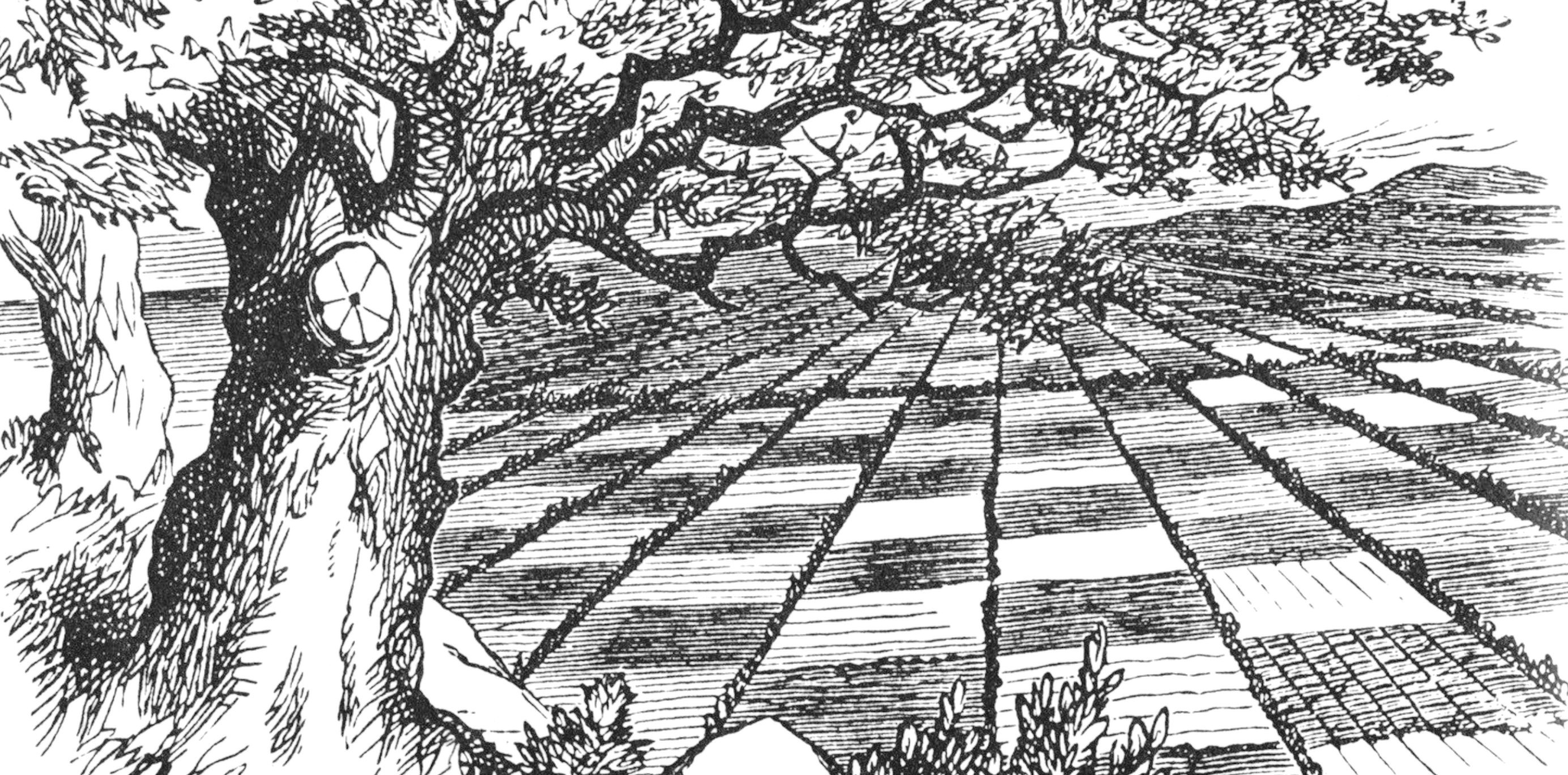
1 | “The chess field”: illustration of the ‘chessboard by John Tenniel, published in the first edition of Lewis Carroll s Through the Looking Glass (1871).
The long–lasting evolution of a water management system
A period of economic and demographic crisis can have a very strong impact on the management of the territory and its resources. This also applies to the ancient world, as shown, for example, by the panegyric dedicated to the emperor Constantine in 312 AD by an anonymous rhetorician, professor and senator of Augustodunum (Autun), who stated:
Iacebat illa civitas non tam moenium ruinis quam virium defectione prostrata, ex quo eam novi census exanimarat acerbitas. Nec tamen iuste queri poterat, cum et agros qui discripti fuerant haberemus et Gallicani census communi formula teneremur, qui fortunis nemini possumus comparari […]
Habemus enim, ut dixi, et hominum numerum qui delati sunt et agrorum modum, sed utrumque nequaquam hominum segnitia terraeque perfidia. Unde enim nobis Remus aut Nervius aut ipse ille de proximo Tricassinus ager aut arator, quorum reditus cum labore contendunt? Quamquam merito quivis ignoscat ipsis cultoribus, quos piget laborare sine fructu. Siquidem ager qui numquam respondet impendiis ex necessitate deseritur, etiam inopia rusticanorum, quibus in aere alieno vacillantibus nec aquas deducere nec silvas licuit excidere. Ita quidquid olim fuerat tolerabilis soli aut corruptum est paludibus aut sentibus impeditum. Quin etiam ipse ille pagus Arebrignus inani fertur invidia, cuius in uno loco vitium cultura perspicua est; nam retro cetera silvis et rupibus invia securarum sunt cubilia bestiarum. Illa autem quae subiecta et usque Ararim porrecta planities fuit quidem, ut audio, aliquando iucunda, cum per singulorum fines continua cultura procursus fontium fossis patentibus evehebat; nunc autem interclusis vastitate meatibus, quidquid humilitate sua fuerat uberius, in voragines
That city lay prostrate, not so much because of the collapse of its walls as because of the exhaustion of its strength, from the time when the harshness of the new census drained it of life. But a complaint could not be made with justice, since we were both in the possession of the fields which had been registered and bound by the common formula of the Gallic census, we who can be compared to no one in our fortunes [...].
For we have, as I have said, both the number of persons which was recorded, and the amount of land, but both are rendered worthless owing to the inactivity of men and the treachery of the earth. For where are we going to find a field or a farmer comparable to those of the Remi, the Nervii or even of our closest neighbours the Tricasses, whose returns match their labour? Although one would fairly pardon the cultivators themselves, whom it irks to labour profit, if a field which never meets its expenses is abandoned out of necessity, especially when you consider the poverty of the country folk, for whom there was no possibility either of draining water off their land or cutting back the woods, reeling under their debts as they were. Thus whatever was once tolerably fertile land has now either degenerated into swamps or been choked with brambles. Indeed, even that famous district, the Arebrignian is spoken about with empty envy, for cultivation of the vine is conspicuous in only one place; for the rest of it, by contrast, is impassable because of forests and rocks, the dens of untroubled wild beasts. That plain, moreover, which lies under it and extends as far as the Saône, was indeed once a delightful spot, as I hear, when uninterrupted cultivation throughout the properties of individual proprietors carried away the overflow from springs in open channels. Now, however, that their courses have been blocked because of desolation, whatever had been very fertile because of the low–lying has been converted into marshes with deep holes. Finally the vineyards themselves, at which the ignorant marvel, have grown so decayed with age that scarcely respond any longer to cultivation. The roots of the vines, the age of which we do not now know, are bound by having been layered a thousand times, and prevent the trenches from reaching the required depth, and the very shoots that they send out are not buried but merely covered, to be washed out by rains and scorched by the sun. Nor can we mark out a place anywhere for new vines, as is customary in Aquitaine and other provinces, since higher up the rocks are broken, and below the low–lying land is subject to frosts (Panegyrici latini, VIII [V], 5, 4–6, 8. Translation by Nixon, Saylor Rodgers 1994).
In the case of the fertile plain of Autun, the uprisings of groups of shepherds and peasants, probably of Celtic origin, who, because of their debts, ravaged Gaul between the III and IV centuries AD, caused such political and social insecurity that the people of the Edui (the oldest allies of the Romans among the Gauls), were deprived of “[…]la volontà e i mezzi stessi per lavorare la terra” (Lissandro, Micunco (a cura di) 2000, 25). This instability led to a forced abandonment of all human activities related to the exploitation of the land for agricultural purposes. Consequently, the entire area was invaded by brushwood and brambles and became unproductive due to the swamps generated by the lack of maintenance of the open canals that were supposed to ensure efficient water flow and the proper functioning of the drainage system. Nature had taken back what culture (i.e. man) had exploited.
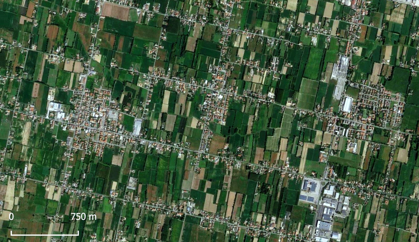
2 | Detail of the centuriated landscape to the north–east of Padova, among Borgoricco, Santa Maria di Sala and Villanova di Camposampiero (Google Satellite, through QGIS 3.10; elaboration by J. Turchetto).
Very often, in the Roman world, the territory was managed through the practice of the centuriation (centuriatio or limitatio) [Fig. 2]. This procedure established not only the regular division of the land into quadrangular lots and their assignment, in private ownership, to the inhabitants of the colonies founded in the conquered territories or to those of the municipal territories, but provided also for land reclamation, the creation of a dense network of canals and the regulation of rivers. The centuriation, indeed, represented a true territorial planning intervention on a large, if not very large, scale, which had to be constantly controlled, maintained and managed. When this control was lacking or loosened, as the words of the panegyrist of Autun remind us, the mechanism began to break down: the canals became obstructed due to the accumulation of deposits, the rivers, no longer effectively regulated, began to overflow onto the plains and change their courses, the waters invaded ever larger portions of the territory, giving rise to marshy and stagnant areas, and crops gave way to spontaneous vegetation and woodland.
It is therefore evident, in a diachronic perspective, that anthropic factors (economic, political, or social crises) and natural factors (climate deterioration, lowering of temperatures, increase in rainfall) have played a major role over time in the preservation or obliteration of the ancient centurial pattern. Indeed, the centuriation is a long–lasting phenomenon, whose outcome is still evident today, but whose evolution over time must be carefully studied, putting together all the possible sources and all the tools we have at our disposal, in order to avoid overly mechanistic interpretations or simplifications which would temporarily flatten the dynamics of transformation/transmission of the ancient agricultural structure.
Phenomena of hydro–geological instability, connected to a decrease in population in late Antiquity, have, for example, contributed substantially to the complete obliteration of the centurial network in the Foglia valley, in the Marche region, south–west of Pesaro (Dall’Aglio, Nesci 2013, 380–381) or to the partial disappearance of the centuriation of the Fidenza plain or of the one north of Reggio Emilia, “[…] dove gli spagliamenti tardoantichi del Crostolo hanno portato alla formazione di una vasta palude, il Gurgum, ancora presente in età comunale” (Dall’Aglio, Franceschelli 2017, 271).
In addition to the phenomena of preservation and obliteration of the centurial grid, episodes of revival after a period of abandonment and partial erasure have also been ascertained. This is the well–known case of the Lugo plain. The agrarian organisation that we can observe there today can be traced back to the reoccupation and restoration of the territory by some monks from Ravenna who, around the year 1000, restored the axes of the centuriation, which had been buried under 4–5 metres of alluvial deposits, lengthening the various limites which could still be seen in the surrounding areas and which must have been preserved because they were traced in morphologically higher and more stable areas (Franceschelli 2016, 188–189).
What, on the contrary, does not seem to have occurred with reference to the Roman centuriation is the debated phenomenon of renormatio, i.e. the superimposition, in the same area, of a series of centurial interventions carried out at different times and with divergent orientations. It is a territorial phenomenon that has been hypothesised, through cartographic and aerophotographic analysis, by the so–called “Besançon School” during the 1980s, and then recalled and strongly supported by French archaeogeographers (for a history of studies on Roman centuriation and for a critical position with respect to these positions see Franceschelli 2016, 179–181 and bibliography cited therein; Dall’Aglio, Franceschelli 2017, 278–280). The presence of agricultural organisations stacked one on top of the other, in fact, would represent, in the opinion of those scholars, a constant in the management of the territory in antiquity, justified by a multipolar vision of space, which, in contrast to our modern way of seeing, was not “[...] ni unique ni unificateur”, nor even less an “[...] élément de cohérence ou élément qui finit par rendre cohérent” (Chouquer 2008, 866–867). As Gérard Chouquer has variously reiterated, “la superposition et l imbrication de deux ou plusieurs trames de limitation a beaucoup intrigué les Modernes au point que cette réalité a souvent été rejetée comme impossible. Il est vrai qu on peut être surpris de ces interférences, d’autant plus que nous sommes habitués à dessins parcellaires et à des plans cadastraux uniques, ce qui donne une base cohérente à l’enregistrement cadastral. Il n en allait pas de même dans les habitudes de division et d’assignation” (Chouquer 2010, 263).
In particular, according to the current of thought of the archeogéographie (Chouquer, Favory 2001, 160–162; Chouquer 2008, 865–866; Chouquer 2010, 263–264), the renormatio could be suggested on the basis of some passages by Pseudo–Agennius, Siculus Flaccus, Hyginus Gromaticus and Marcus Iunius Nipsus. However, from a re–reading of the Gromatici Veteres it appears quite evident that there was a forcing in the interpretation of their meaning, which, in reality, would lead to the exclusion of the systematic application of the practice of re–centuriation in Roman times. Indeed, as Maria Pia Muzzioli already recalled (Muzzioli 2010, 48–49), interventions of renormatio, with the overlapping of centurial axes with different orientations, would have also destroyed the entire agricultural system of the territory, from the rows of trees, to the vines (“che sono il patrimonio del campo e non si sostituiscono in breve tempo”), to the network of canals, ditches and collectors created for hydraulic regulation and land reclamation, up to the road which constituted the backbone of the centurial system itself and which was connected to the main road network. Therefore, the infrastructures that could guarantee an effective agricultural exploitation of the territory and make the land productive would have been destroyed, through an operation that, all in all, would have proved to be very expensive and also completely useless. If things work, indeed, why would it be necessary to intervene to change them?
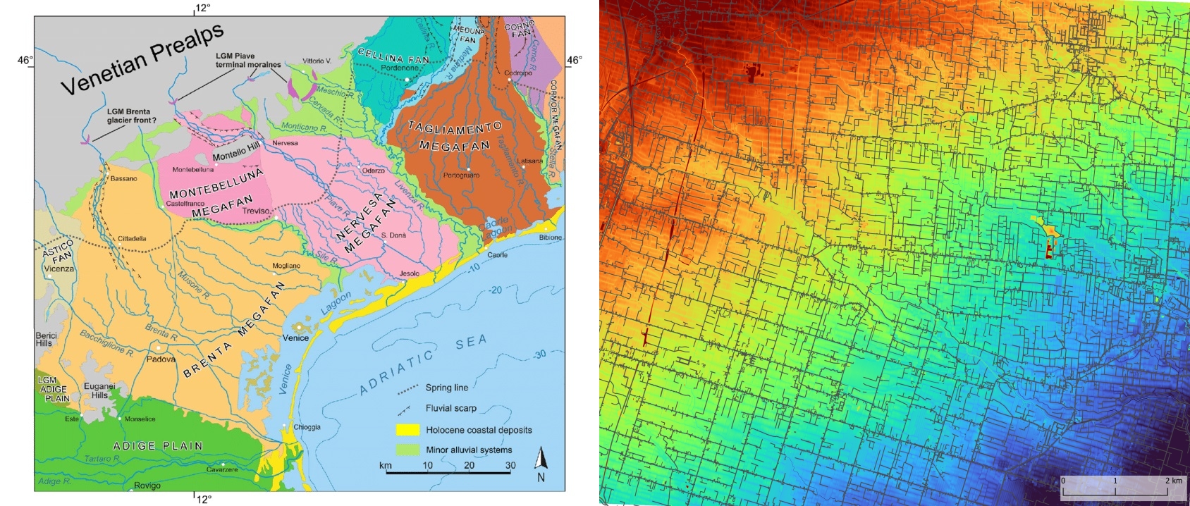
3 | The megafans of the Venetian–Friulian Plain (from Mozzi, Ferrarese, Fontana 2013).
4 | The border between the centuriations of Padova (to the south–west) and Altino (to the north–east) (QGIS elaboration by J. Turchetto).
Approaching the centuriations of Padova and Altino from a diachronic perspective
The diachronic dynamics of persistence, obliteration and revival can also be detected in the Roman agricultural organisation that can still be identified today in the central Venetian plain, roughly comprised among the Brenta, the Sile and the lagoon margins [Fig. 3]. From a geomorphological point of view, it is an area that corresponds to the distal portions of the Pleistocene sector of the Brenta of Bassano megafan, which stretches in a north–west / south–east direction starting from the outlet of the Brenta Valley in the plain (Valsugana), up to the edge of the Venice lagoon near Mestre. Unlike the sector of the so–called high plain (characterised by gravelly–sandy sediments), the entire area south of the Sile (low plain) “is composed of soils consisting mostly of siltyclay deposits”. The transition zone between these two sectors is the resurgence line, a territorial strip between 2 and 10 km wide, in which the rising of part of the water table is induced by the presence of impermeable horizons. The different composition of the soils also entails a different characterization at the hydrographic level between the high plain, which is almost devoid of surface water, because it is particularly draining, and the low silt–clay one, which is rich in water and resurgence rivers, such as the Musone, the Marzenego, the Dese or the Zero (Fontana, Mozzi, Bondesan 2004; Mozzi 2004; Bondesan, Meneghel 2015).
Within the framework of a rational agricultural organisation of this territory in Roman times, the presence of abundant surface waters played a central role not only in the creation of the two centurial systems (one pertaining to Padova and the other to Altino, separated by the course of the Musone), but also, subsequently, in their different state of conservation [Fig. 4]. As far as the countryside of Padova is concerned, in fact, we can easily recognise a phenomenon of exceptional survival of the limits (represented above all by roads and canals), which still today can be read clearly through carto–photo–interpretation, both in the case of axes laid every 20 actus between one centuria and another, and of the intercisivi ones placed within them. The reasons for the persistence could be found, on the one hand, in the fact that that the whole sector was crossed by resurgence rivers with a limited flow and, therefore, potentially not very dangerous; on the other hand, in the inability of the early Medieval political–administrative structures to intervene in incisive terms on the territory and its organisation; furthermore, in the constant laborious efforts of the late medieval rural communities to clean the canals and strengthen the embankments (Bortolami 2012, 137, 143, 195).
The countryside of Altino, on the other hand, presents more fleeting traces and the overall design is not always easily reconstructable in detail. In this case, some explanation could derive from the punctual analysis carried out by Matteo Frassine, from which it can be deduced that “[...] la maggior parte dei limiti conservati è composta da strade campestri (42%) e da canalizzazioni (36%), mentre solo al terzo posto si collocano le strade (17%) e all ultimo quei segni coincidenti con l idrografia (5%)” (Frassine 2015, 71–72).Therefore, since it is a centurial grid which was materialised, in most cases, through an artificial network of canals and drains and since that sector is characterised by rivers with a much more consistent flow, the lack of systematic maintenance of the entire system could have led, as in the case of the Autun plain, to an (at least partial) obliteration of the limites [Fig. 5].
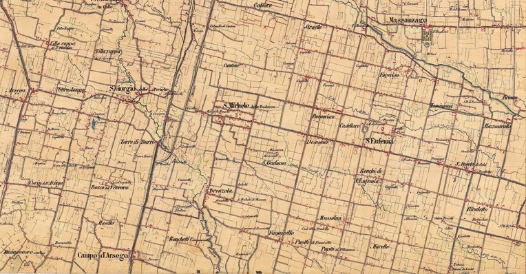
5 | Detail of the 10.XVI map of the Second Military Survey (1825) of the area of the centuriations of Padova (with limites represented mainly by roads) and Altino (with limites represented mainly by canals and rural roads).
Moreover, episodes of revival seem to have occurred in some sectors of the centuriation to the north–east of Padova, such as Arsego or San Giorgio delle Pertiche, where the regularity of the present situation, in which a rational organisation of the landscape can easily be recognised, is not reflected in the historical cartography of the early 19th century. Comparing modern aerial photographs (GAI flight of 1955) and, in particular, the Kriegskarte by Anton von Zach (1798–1805), it appears clear that various limites have been (re)traced by adapting to the orientation suggested by the decumani and kardines which were preserved in the neighbouring areas (Lachin 2010, 42, 44–45).
The possibility of being faced with a re–centuriation phenomenon, on the other hand, appeared starting from the end of the 1970s, following the discovery, through a remotely sensed analysis of satellite images, of lineations buried in the Veneto–Friuli plain interpreted as Roman centuriation axes. The most disruptive aspect of that discovery, subsequently corroborated by analyses conducted on the basis of more recent satellite images, was that new systems of lineations were identified, despite they had been never documented before through carto–photo–interpretation, and which overlapped the already known centuriations, with divergent orientations [Fig. 6]. What was attempted, therefore, was a stratigraphic investigation that could confirm the existence of a relative chronological seriation of the various centurial systems identified, since these seemed to “coprire o essere coperti da altri o essere meno visibili sul terreno perché sepolti etc., indicando così una sequenza temporale” (Lachin 2010, 47). The hypothesis was then advanced of the existence, in a period between the lex Pompeia de Transpadanis of 89 BC and the municipal law of 49 BC, of a territorial framework characterised by two very large centuriations gravitating around Patavium and Altinum. In particular, it was hypothesised that the agricultural division of Padova extended even beyond the course of the Musone Vecchio and reached the Piave, while that of Altino extended between the lower courses of the Sile, those of the Piave and that of the Livenza. In these terms, the first could have guaranteed a certain level of protection at the mouth of the Piave valley, in correspondence with the first dolomitic reliefs, and of the entire foothills of Treviso; while the second would have placed itself in control not only of the Piave directrix, but also of the entire district of Opitergium/Oderzo.
In the second half of the I century BC, however, new and changing needs (i.e., the battle of Philippi, the war of Perugia, the decisive battle of Actium, the difficult management of veterans and the development of centres, such as Opitergium and, above all, Tarvisium, with increasingly Roman connotations) perhaps led to a territorial reorganisation inducing a large–scale phenomenon of re–centuriation of the Venetian plains (Lachin 2010, 49; Rosada, Lachin 2013, 33). In particular, in the sector between Musone Vecchio, Sile and Piave, there would have initially been a contraction of the agricultural division of Padova and, in that left free area, a new centuriation of Altino would have been created, i.e. the one we can still observe today. Furthermore, in a phase that is not easily identifiable, perhaps at the same time or later, the countryside of Altino would have ceded portions of territory to the benefit of the development of neighbouring municipalities: the sector between Piave and Livenza would have become part of the countryside of Opitergium (whose renewed agricultural structure would have obliterated the traces of the previous centuriation of Altinum, which, being older, are in fact no longer visible either in cartography or on the ground); while a large portion of the territory between Sile and Piave would have been incorporated into the countryside of Tarvisium.
As already mentioned, however, it is difficult to accept a systematic use of renormatio in the Roman period. Precisely for this reason, the satellite images that had led to the discovery of the buried systems have recently been analysed again, with new and more refined instruments. The result is that there is, in no case, evidence of the very numerous lineations which should have formed the large overlapping agricultural systems mentioned above (Turchetto 2022, 104–136) [Fig. 7]. In this specific case, the traces seem to be evanescent because they are found on supports that are not particularly precise or in high–resolution, and were reasonably stimulated by a certain enthusiastic optimism which perhaps has led to reconstructing, in retrospect, what in reality most likely did not exist at all. We must not forget, indeed, that photointerpretation for archaeological purposes must always comply within limits that take into account, not only the variability of the legibility conditions of the terrain and the shooting methods, but also the additional disturbances, known as ‘false traces’ which can lead to errors of interpretation. The anthropic traces identified may correspond to traces actually existing on the ground, but not necessarily due to archaeological or datable elements, even if they have a very similar typology (Zamboni 2002, 48, 50).
Moreover, if we consider the Roman centuriation as a territorial organisation also aimed at the management of surface waters, it appears even more evident that the overlapping of groups of lineations with divergent orientation would have completely undermined the previous drainage and runoff system. In this perspective, therefore, we can better understand the genesis and development of the two agricultural systems of Padova and Altino, which, within the framework of a reasonable unitary and systematic territorial structuring, found their own shared border in the course of the Musone river and were defined with two distinct orientations. Such different inclinations, however, did not originate from the practice of renormatio, but simply from the political will to distinguish, as it is suggested by Roman surveyors (Front., De limit.,31, 7–9, Lach.), the territories belonging to two different cities.
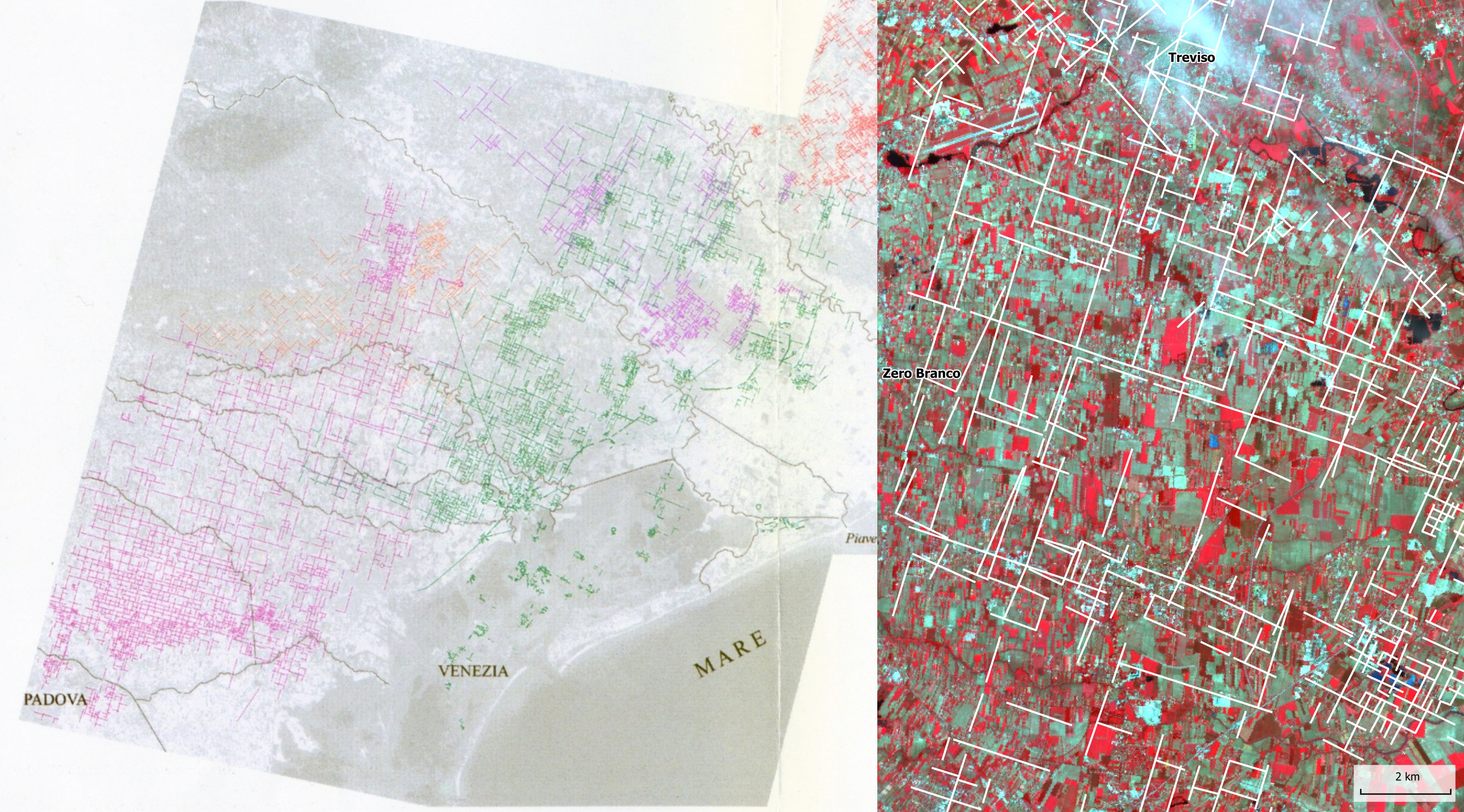
6 | Superimposed systems of lineations detected by Baggio and Sigalotti in 1999, by analysing SPOT and Landsat satellite images (modified from Turchetto 2022).
7 | Detail of the RGB composition (1–2–3) of the multispectral image SPOT 1 (date of capture: June 9, 1989) and superimposition of the traces identified by Baggio and Primon in 2000 (from Turchetto 2022).
Enhancing the centuriated landscape through slow tourism
The detour called ‘The ring of the centuriations , planned to accompany pilgrims travelling along the Romea Strata and Saint Anthony s Path to discover the centuriations of Padova and Altino, aims at making the history of that corner of the Veneto plain better known. There, past and present merge in an efficient water management system, by exploiting the same mechanisms set up by the Romans more than two thousand years ago. In this perspective, precisely to enhance both the historical–cultural and naturalistic aspects linked in particular to water and rivers, a cycling itinerary has been planned around the course of the Musone Vecchio river, along the stretch between Camposampiero and Stigliano. Indeed, that is the line that in Roman times should have represented the shared border between the centuriation of Padova and that of Altino and, in the Middle Ages, the north–eastern border of the territory of Padova, as it is suggested in the seal of the city: Muson, mons, Athes, mare certos dant michi fines (‘The Musone, the mountain, the Adige, the sea clearly mark my boundaries ) (Bortolami 2012, 129).
Halfway along the route, near Massanzago, a network of orthogonal roads allows to reach the Museum of the Roman Centuriation of Borgoricco and to experience the geometric regularity of the Roman layout. Instead, the banks of the Marzenego river, near Noale, lead through the centuriation of Altino in the direction of Piombino Dese, where a beautiful stretch of the Treviso–Ostiglia cycle path, created along the old military railway line, permits to reach Camposampiero, thus concluding the tour.
The enhancement of the centuriated landscape is provided by a series of narratives, developed as a support for a thematic featured trip across the territory around the Municipality of Borgoricco. In this way, pilgrims are offered the opportunity to gain a great variety of in–depths focuses about both cultural and natural aspects ranging from antiquity to modern times: history of transportation, from Roman roads to military railways and cycling paths; man struggling with the geomorphology of a territory of resurgences; the role of Roman centuriation in the history of the territory of the central Venetian plain; the implication of a correct water management in a flat landscape; water as a resource: the mills and the tradition of silkworm breeding along the Musone river.
All this will contribute to a better knowledge of the whole district, and furthermore to boost the attention and the curiosity on an often neglected Roman territorial monument.
Bibliography
Sources
- Lissandro, Micunco (a cura di) 2000.
D. Lissandro, G. Micunco (a cura di), Panegirici latini, Torino 2000. - Nixon, Saylor Rodgers 1994
C.E.V. Nixon, B. Saylor Rodgers, In praise of later Roman Emperors. The Panegyrici Latini, Berkley–Los Angeles–Oxford 1994.
References
- Bondesan, Meneghel 2015
A. Bondesan, M. Meneghel, 5.14 Il megafan di Bassano, in A. Bondesan, S. Busoni (a cura di), Geomorfologia della Provincia di Treviso, Crocetta del Montello (Treviso) 2015, 108. - Bortolami 2012
S. Bortolami, Il graticolato in età medievale tra persistenze e innovazione, in C. Mengotti, S. Bortolami (a cura di), Antico e sempre nuovo. L agro centuriato a nord–est di Padova dalle origini all età contemporanea, Sommacampagna (Verona) 2012, 125–221. - Carroll 1871
L. Carroll, Through the Looking–Glass, and What Alice Found There, London 1871. - Chouquer 2008
G. Chouquer, Les transformations récentes de la centuriation. Une autre lecture de l'arpentage romain, “Annales. Histoire, Sciences Sociales” 4 (2008), 847–874. - Chouquer 2010
G. Chouquer, La terre dans le monde romain: anthropologie, droit, géographie, Paris 2010. - Chouquer, Favory 2001
G. Chouquer, F.Favory, L’arpentage romain. Histoire des textes – Droit – Techniques, Paris 2001. - Dall’Aglio, Franceschelli 2017
P.L. Dall’Aglio, C. Franceschelli, La centuriazione della pianura padana: criteri ricostruttivi e problematiche storiche, in E. Lo Cascio, M. Maiuro (a cura di), Popolazione e risorse nell Italia del nord dalla romanizzazione ai Longobardi, Bari 2017, 255–287. - Dall’Aglio, Nesci 2013
P.L. Dall’Aglio, O. Nesci, Storia e geografia fisica del territorio costiero tra le foci dei fiumi Metauro e Foglia, in F. Raviola (a cura di), L’indagine e la rima. Scritti per Lorenzo Braccesi, Roma 2013, 439–451. - Fontana, Mozzi, Bondesan 2004
A. Fontana, P. Mozzi, A. Bondesan, 3. I. L’evoluzione geomorfologica della pianura veneto–friulana, in A. Bondesan, M. Meneghel (a cura di), Geomorfologia della Provincia di Venezia. Note illustrative della carta geomorfologica della provincia di Venezia, Padova 2004, 113–138. - Franceschelli 2016
C. Franceschelli, Riflessioni sulla centuriazione romana: paradigmi interpretativi, valenza paesaggistica, significato storico, “Agri Centuriati” 12 (2015), 175–211. - Frassine, Primon 2015
M. Frassine, S Primon, L’agro di Altino: lineare complessità di un territorio centuriato, “ATTA” 25 (2015), 63–88. - Lachin 2010
M.T. Lachin, Una storia della terra: leggere il paesaggio agrario a nord–est di Padova, in P.L. Dall’Aglio, G. Rosada (a cura di), Sistemi centuriali e opere di assetto agrario tra età romana e primo medioevo, Atti del Convegno (Borgoricco–Lugo, 10–12 settembre 2009), “Agri centuriati” 6/2009 (2010), 39–52. - Mozzi 2004
P. Mozzi, Tra Sile e Naviglio Brenta, in A. Bondesan, M. Meneghel (a cura di), Geomorfologia della Provincia di Venezia. Note illustrative della carta geomorfologica della provincia di Venezia, Padova 2004, 260–265. - Mozzi, Ferrarese, Fontana 2013
P. Mozzi, F. Ferrarese, A. Fontana, Integrating digital elevation models and stratigraphic data for the reconstruction of the post–LGM unconformity in the Brenta alluvial megafan (north–eastern Italy), “Alpine and Mediterranean Quaternary” 26 (1) (2013), 41–54. - Muzzioli 2010
M.P. Muzzioli, Le ricerche sui resti della centuriazione cinquant anni dopo, “ATTA” 20 (2010), 7–49. - Rosada, Lachin 2013
G. Rosada, M.T. Lachin, Assetti centuriati romani. Problemi di metodo a partire dai casi della Venetia et Histria, in M. Prevosti, J. López Vilar, J. Guitart i Duran (eds.), Ager Tarraconensis 5. Paisatge, poblament, cultura material i història, Actes del Simposi internacional, Tarragona 2013, 23–35. - Turchetto 2022
J. Turchetto, Una, nessuna, centomila…tracce di centuriazione romana nella Venetia centrale. Sguardi oltre le linee, Padova 2022. - Zamboni 2002
C. Zamboni, Il contributo del telerilevamento: le evidenze archeologiche, in F. Ghedini, A. Bondesan, M.S. Busana (a cura di), La tenuta di Ca’ Tron. Ambiente e storia nella terra dei dogi, Sommacampagna (Verona) 2002, 46–55.
Abstract
Starting from the assessment of the impact of an economic–demographic crisis on the landscape, the contribution describes the possible transformations to which the Roman land division could be subject in the longue durée. Subsequently, these results are briefly illustrated starting from the specific cases of the agrarian organisations of Padova and Altino, which represents the main topic of the cultural detour called ‘The Ring of the Centuriations’. This is dedicated to the discovery of an often–neglected territory, which instead deserves to be reconsidered and enhanced due to its historical and cultural value
keywords | Roman Centuriation; Water Management System; Diachronic Perspective; Venetia; Via Romea Strata.
All contributions to this issue of Engramma have followed invited submission and have been reviewed by the editorial board and scientific committee of the journal.
To cite this article: Jacopo Turchetto, The Roman centuriations of Patavium and Altinum. A water management system in the central Venetian plain, “La Rivista di Engramma” n.204, luglio/agosto 2023, pp. 93-106 | PDF of the article